Wednesday, March 30, 2011

Snow amounts from today, and Thursday's forecast!

Good evening! The snow from earlier today is gone! That was impressive for the next to last day of March! Here is a picture of the amount of snow at the NWS office:


1.5" of snow fell today in Indianapolis today! Including this event, there have only been 5 other times on this date that measurable snow fell on this date. The last time this much snow fell on this date was in 1942! Sorry if I am boring you guys!

Tonight: Skies will continue to clear, and it will be COLD! Lows may dip into the mid 20s. If you have any blooming flowers such as daffodils, you better cover them!

Tomorrow: It should really be a nice day! The sun will be shining, and temperatures will respond! Highs may near 50 in Indy, upper 40s north of Indy, and low 50s south of Indy. I know I could do a lot better, but it could be worse! Tomorrow will be the best weather day so far this week.

I will have an update later tonight on the long term, and when a warm up comes! Have a good evening, and be sure to check back later!

Tuesday, March 29, 2011

Snow in spring!

Good evening! Thanks for looking at my blog! Sorry my updates have been few lately, I am just enjoying spring break! There is a system moving in tonight and here is the breakdown:

-Dry this evening

-Light snow/rain moves into Bloomington, Columbus, Bedford, Vincennes after midnight

-Light snow will make it to the I-70 corridor towards 2-5 am

-Snow moves out by 9am

-Snow accumulations between a 1/2"-1" along and south of Bloomington and Columbus. A dusting is possible on the south side of Indy, and Martinsville, Franklin, Shelbyville areas.


                         Have a great evening!


Monday, March 28, 2011

Looking ahead!

Good evening! Today turned out to be a decent day of weather. Highs hit the 40s areawide. Clouds will move in later tonight, with lows in the upper 20s-near 30. If you have any blooming flowers, be sure to cover them tonight! Here is the extended forecast:

-Tuesday: partly sunny, shower south. Highs 45-50.

-Wednesday: am mix, mostly cloudy. Highs 45-50.

-Thursday: partly sunny, not too bad! Highs 47-52.

-Friday: cloudy, a few showers. Highs 48-53.

The weekend: The latest data is trending a bit cooler and delaying the warm-up. Saturday should be pretty nice with some sun, and highs in the low 50s. Sunday will warm in the upper 50s with late day showers possible.


                   Have a good night!

Monday Afternoon Forecast

Good afternoon! I hope everyone is having a good start to spring break! The weather this afternoon will feature sunshine, and breezy conditions. Highs will hit the mid 40s in Indy, low 40s north of Indy, and upper 40s south of Indy. I will look at the latest model data this afternoon, and I will have an update later this afternoon on when we may see more snow, and a warm-up. Have a good afternoon!

Sunday, March 27, 2011

Sunny, but chilly day, and looking ahead!

Good morning! There was some crazy accumulating snow that fell across southern Indiana and north-central Kentucky. A widespread 1-3" fell in that area last night. The snow and clouds have moved out, so today should be a bright day outside! Snow will melt off very quickly and will be all melted by later today. Highs will hit the upper 30s in northern Indiana, near 40 central, and mid 40s south. Tonight, there may be another round of snow for extreme southern Indiana and Kentucky. Here is the detailed for the rest of our spring break:

-Monday should be a decent day with sunshine, and highs in the mid 40s central, low 40s north, and upper 40s in southern Indiana.

-Clouds will increase on Tuesday with showers by evening. Highs will hit the upper 40s central, mid 40s north, and near 50 south.

-A wintry mix is possible Wednesday morning, with highs on Wednesday only in the low 40s.

-Thursday and Friday will be mainly dry with mid 40s Thursday, and near 50 Friday.

    Our spring break won't really have any spring feel to it! Remember last year? We had highs in the 80s for the second half of our break! Not this year! :( We should see an abrupt warming trend next weekend, and we are in a pattern where we should warm back up quickly after the first week of April. The weather pattern will probably be a very active one as we head into the middle and end of the month. Here is the GFS 348 hours out:


                                                Have a great Sunday!

Saturday, March 26, 2011

Snow for southern Indiana tonight!

Good afternoon! I apologize for not updating at all yesterday. We were waken up early this morning here in Memphis due to strong storms and power outages. Luckily, the power is back on!! Up in central Indiana, you guys are enjoying sunshine and chilly temperatures. Clouds will increase this afternoon, but things will stay dry. However, snow will break out across south-central and southern Indiana overnight. I am only expecting a dusting in Indy metro, but areas south of Bloomington could wake up to a couple inches of wet snow. This includes all of southern Indiana! I know most people have put their shovels away, but this is about as late as it gets for accumulating snow, especially for southern Indiana and Kentucky. Parts of central and northern Kentucky could wake up tomorrow morning to a 1-2" snowfall. The models still aren't sure where the snow will fall. Here are some maps..........
 So which model will pan out? I really think the NAM is doing a great job on the snowfall staying south of central Indiana. If this is right, Indy won't get any snow :) I think with a high pressure to the north, that should suppress the snows south of central Indiana. Have a great Saturday!!

Thursday, March 24, 2011

Snowfall map for Saturday night!

Good evening! I have created a scribbly map of the snowfall amounts for Saturday night. Here it is..........

\
  I think areas like Bloomington, Columbus, Bedford, and Seymour are in the bullseye for a good 3" of wet snow. Here is the NAM snowfall amounts:


 I really hate this!!! I do like snow, but snow should fall when it's supposed to, not in the SPRING! How would it be to go sledding on spring break? Crazy! If you have plans to travel Saturday evening, especially south of Indy, you really need to stay tuned to the blog. Have a good night, and check back tomorrow morning for the update on the weekend snowfall potential.

Cold pattern takes hold, along with accumulating snow?

Good morning! Isn't it shocking cold out this morning? With the storms that moved through last night, the main thing was the hail. Up to 2" thick in spots! After being well in the 70s the past three days, our weather is getting really cold, and it will be in no hurry to move out! Today will be miserable with drizzle this morning tapering off this afternoon, along with blustery winds. Highs will hit the low 40s. Tomorrow will not be much better with partly sunny skies, late day showers, and highs only in the low-mid 40s.

 WEEKEND: There is snow in the forecast this weekend! A rain/snow mix will develop Saturday. That will switch to all wet snow Saturday night. I am going with a 1-2" snowfall in central Indiana, with isolated higher amounts possible. I hope you haven't put the shovels away, we may have a covering of white to start our Sunday morning! Isn't that rediculous! Sunday will dry out and stay chilly with partly sunny skies. Check out the models and snowfal totals for the weekend.......

Keep in mind that we will not see totals as high as the NAM model above shows, but any snow this late in the year is impressive.

SPRING BREAK: We will start out next week cloudy, with another system for late Monday into Tuesday. This will likely be another mix for us, and highs struggling to hit 40. By the middle and end of next week, we will see a gradual improvement in temperatures, but still below average! :( I am so sorry about that spring break forecast. Maybe some slushy snow for SPRING break? That is crazy! Check out the long range models, and how long this cold snap may last:

 Have a great Thursday, and I will be heading to Tennessee either late tonight or tomorrow. I can update the blog from my phone, so the blog will stay updated as always! Have a great Thursday, and stay warm!

Wednesday, March 23, 2011

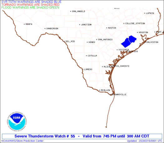
Tornado Warnings for eastern Indiana!

Good afternoon. Sorry I didn't have an update this morning. Busy,busy! We have some wild weather going on that is really important to address right now. The cold front was able to pass Indy before the instability really got going. We have severe t'storm and tornado warnings out for eastern Indiana, along with a tornado watch. Some counties under a Storm Warning are Orange, Martin, Daviess, Washington, Lawrence, and several more in Eastern Indiana. Tornado WARNINGS include Jackson, Decatur, and Rush counties. These storms will move southeast as the afternoon progresses. Here is a map of the warnings..........
WW0055 Warnings
  If your county is under a tornado warning, or you here the sirens go off, take shelter IMMEDIATELY! Now here is the radar to track this outbreak for southeast Indiana and Kentucky......


 By the minute, more counties will continue to be under warnings. Most of the western half of central Indiana, and all of northwestern Indiana will escape these storms. Even under a severe storm warning tornados can form! Check back for more updates, and stay safe if you live east or southeast!

Tuesday, March 22, 2011

Another warm day, tracking BIG changes!

Good Tuesday. Hopefully everyone was able to get out yesterday! Indy was only 2 away from 80! Today will be somewhat cooler, but still very nice. Highs will range from mid 50s north to near 70 in Indy, and mid 70s today in southern Indiana. Northern Indiana will stay cool because of rain. Track the rain here.....

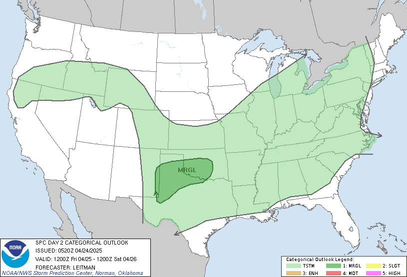
  Tomorrow will be the last warm day as highs hit 70 along with some showers and storms. Severe storms are very possible tomorrow afternoon for southeast Indiana and Kentucky:
SPC Day 2 0600Z Outlook Categorical

  A MAJOR pattern change will take hold starting Thursday and likely continuing through early April. The weather this weekend looks nasty with a mix possible on Saturday. Sunday should be mainly dry and cold before the next system moves in. This system is going to take a track that could produce a wintry mix in central Indiana, possibly light accumulating snow north? This is absolutely absurd for early spring! Here are the models for early next week....

 Look at that arctic air! Probably only in the 30s for highs by next Monday, with a gradual warm-up through our spring break. There is some good news though... you may recall me saying a few weeks ago that there has been a lot of cold air locked up in Canada. What needs to happen is for all the cold air to get sweeped out of Canada before TRUE spring can begin. This pattern will likely take out most of the cold in Canada and I think once we pass early April, our "true" spring can begin. But this pattern is definately not a good one for spring break! On the map below for next Tuesday, notice the well below average temperatures for us and the above average temperatures for Canada.........

 That is all for today! Have a great Tuesday, and check back later for more updates!

Monday, March 21, 2011

False start to spring?

Good evening! Before I get to the depressing part of the forecast, wasn't today's weather awesome? 77 degrees in Indy today, 82 in Louisville! This is average for mid-late May. Tomorrow we should see temperatures in the same territory with only spotty showers and storms expected. Any storm that pops up could be severe. More widespread storms are likely Wednesday. After that, well....... do I have to talk about it? It will be COLD with low-mid 40s for highs. Rain is likely for both days this weekend, with mid 40s for highs. A system will slide south of our area next Monday, so temperatures could be cold enough for a wintry mix here in central Indiana, with possibly accumulating snow in northern Indiana. That is a rediculous forecast for the last week of March! On a side note... a few days ago someone asked me where I get my weather infomation from. It comes mainly from a consensus of these 3 forecast models: GFS (general forecasting system), NAM (North America Mesoscale), and European models. I would never base my forecast from what media says because that would be basically copying, and there wouldn't be much need for this blog! Have a good night, I will have more info on next week's forecast tomorrow morning!

70s for the next couple days, low 80s for southern Indiana? Also looking ahead to the spring break weather outlook!

Good morning! It is a warm start out this morning! We have a few showers in eastern Illinois this morning. The showers today should be rather spotty, but you can track the rain and warm temperatures here:
Indiana Temperature Map


Tuesday: It looks like tomorrow should be a mainly dry day with partly sunny skies. Temperatures will be VERY warm! Mid 70s are likely for central Indiana, upper 70s-low 80s for southern Indiana, and low 70s far north. Get out the shorts tomorrow! :)

Wednesday: This is when a cold front will near the area. Some scattered showers and storms are likely. Highs should hit 70 in most places.

Thursday-Sunday: This period looks cold with some chances of rain coming up late Saturday and Sunday. Highs on Thursday and Friday will be in the 40s. Temperatures on Saturday will depend on when the next system arrives, but staying chilly. Rain is expected on Sunday, with highs in the 40s. :(

SPRING BREAK OUTLOOK: It may be a chilly spring break. Here are some models:


This is not a good sign at all for warm weather lovers! I know some people like to start their gardens on their spring break. With freezing overnight temperatures, you may want to rethink it! I am really sorry for the depressing spring break forecast. It may not feel like spring! :(

       Have a good Monday and check back for updates later today!

Sunday, March 20, 2011

Overnight Forecast, and 70s tomorrow!

Good evening! It was very warm, almost an early summer prelude today for southern Indiana, and rather mild in central Indiana. Southern Indiana saw mostly sunny skies, so highs soared in the mid-upper 70s. I spent the afternoon out in shorts! The high in French Lick was 76 today! It was about 10 degrees cooler in Indy thanks to morning rain and thicker clouds, and near 70 in Bloomington today. Skies have become mostly clear this evening, and winds have lightened, so temps are falling somewhat. They will not fall off much tonight thanks to warm air advection. There will be some instability after midnight, so an isolated shower or storm is possible. The question tomorrow morning will be a jacket or no jacket? Perhaps a light jacket as you head out, but we will be about warm enough for shorts tomorrow afternoon. Highs will hit the low 70s in central Indiana, upper 60s north, and mid 70s south. Isolated showers or storms will be possible, but otherwise partly sunny and dry. The warm weather will continue through midweek, then a BIG cold snap. There are some impressive amounts of cold showing up on the models. I will post some of the weather models, and what weather pattern we can expect for spring break. Have a great night, check back tomorrow morning!

Your Sunday Afternoon Forecast

Good Morning. Here is the outlook for Indiana this afternoon:

*Southern Indiana- partly sunny and nice. Highs in the upper 60s-low 70s.

*Central Indiana- scattered showers tapering off by this afternoon. A few peeks of sun. Highs in the upper 50s- mid 60s.

*Northern Indiana- scattered showers through the afternoon. Highs in the mid 50s.


     Have a great Sunday afternoon!

Saturday, March 19, 2011

Supermoon tonight creating an increased threat of earthquakes, and looking ahead to a warm-up before a MAJOR cold snap!

Good evening! Thanks for looking at the blog. As the sun is setting, look far in the east and you will see the "supermoon." It will be sort of dim because of high clouds. This "supermoon" could cause some earthquakes that may be felt around here. Read this story from the European Union Times:

According to a tale making the rounds on the Internet, the Institute of Physics of the Earth told Prime Minister Putin that there will be another mega quake by the end of March 2011, most likely in the Americas along the New Madrid fault line. The story goes that the levels of electromagnetism in the upper atmosphere are rising in this particular zone.
There may be something to it. According to the Associated Press, a week-long “rare training event” involving the U.S. Military and the CIA will be held 21-25 at Fort Leavenworth in Texas. The U.S. Treasury, U.S. State departments, U.S. Agency for International Development, the Defense Threat Readiness Agency and the International Red Cross as well as officers of the Canadian Forces College will all be attending.

The state of Arkansas is said to have had 600 tremors over the past six months, although it is suspected they some be related to natural gas “fracking” (hydraulic fracturing) in the region.
********************************
********************************
We've received a number of email in regards to chances for more earthquakes.  While we're not geologists we try to keep up with the latest news.  Here's a release we received... take it for what it's worth... we've not been able to confirm its authenticity.
According to a tale making the rounds on the Internet, the Institute of Physics of the Earth told Prime Minister Putin that there will be another mega quake by the end of March 2011, most likely in the Americas along the New Madrid fault line. The story goes that the levels of electromagnetism in the upper atmosphere are rising in this particular zone.
There may be something to it. According to the Associated Press, a week-long “rare training event” involving the U.S. Military and the CIA will be held 21-25 at Fort Leavenworth in Texas. The U.S. Treasury, U.S. State departments, U.S. Agency for International Development, the Defense Threat Readiness Agency and the International Red Cross as well as officers of the Canadian Forces College will all be attending.

The state of Arkansas is said to have had 600 tremors over the past six months, although it is suspected they some be related to natural gas “fracking” (hydraulic fracturing) in the region.
EARTHQUAKE WARNING FROM RUSSIAN INSTITUTE of PHYSICS of the EARTH
A new report released today in the Kremlin prepared for Prime Minister Putin by the Institute of Physics of the Earth, in Moscow, is warning that the AMERICA’S ARE IN DANGER OF SUFFERING A MEGA-QUAKE OF CATASTROPHIC PROPORTIONS DURING THE NEXT FORTNIGHT (14 days) with a specific emphasis being placed on the UNITED STATES, MEXICO, CENTRAL AMERICA AND SOUTH AMERICAN WEST COAST REGIONS along with the New Madrid Fault Zone region.This report further warns that catastrophic earthquakes in ASIA and the sub-continent are, also, “more than likely to occur” with the 7.3 magnitude quake in Japan today being “one of at least 4 of this intensity” to occur during this same time period.Raising the concerns of a mega-quake occurring, this report says, are the INCREASING SUBTLE ELECTROMAGNETIC SIGNALS that are being detected in the Earth’s upper atmosphere over many regions of the World, with the most intense being over the US Western coastal and Midwest regions.Important to note are that Russian and British scientists are at the forefront of predicting earthquakes based on these subtle electromagnetic signals and have joined in an effort to put satellites in space to detect more of them.More ominously in this report are Russian scientists confirming the independent analysis of New Zealand mathematician and long-range weather forecaster, KEN RING, who predicted the deadly Christchurch quake and this week issued ANOTHER WARNING OF A QUAKE to hit on or about March 20th.
Ring explains his methodology for predicting earthquakes as follows:“The planets very much affect the earth, indirectly, by having an effect on the Sun. Some planets are very large. If the Sun was a basketball the gas giants Jupiter and Saturn would be the size of grapefruits, and the Earth would be, on that scale, the size of a peppercorn.
Jupiter and Saturn cause extra tides on the Sun when they get on either side of the Sun (as with Moon – Earth-Sun when the moon is full) and when these gas giants get on the same side as the Sun, (as with Earth -Moon – Sun when the moon is new).
These greater solar tides become sunspot activity and solar flares and can be understood as akin to the increase in tides caused by the Moon when it too gets alongside Earth or opposite Earth.
At the moment we have Jupiter and Saturn on either side of the Sun and creating a tug of war with Earth in the middle. That started last September and will continue until about May.
In September the Earth was right in line with Jupiter, Saturn and the Sun too.
That’s why there were several 7+ earthquakes around, it wasn’t just us.
For instance there was one in Pakistan on the same day as Christchurch. This Jupiter/Saturn alignment continues until about May, and the Earth comes back into line as well in March.It is why there MAY BE AN EXTREME EVENT, perhaps a large earthquake, AROUND 20 MARCH, which is when the Moon may be again in a trigger position.”
According to this report, however, where Ring is correct in assessing blame for our Earth’s earthquakes on the Sun and Planets, his substituting of Perigean Spring Tides (also known as King Tides) for the low pressure systems associated with them may be incorrect.
The mention in this report of MASSIVE LOW PRESSURE SYSTEMS being associated with catastrophic earthquakes is especially dire to the United States Midwestern region, which even today is continuing to be pounded by horrific rainfall amounts, and most especially impacting the NEW MADRID FAULT ZONE STATE OF ARKANSAS which has suffered over 800 earthquakes in the past 6 months alone.
Equally in danger, this report continues, is the South American Nation of BOLIVIA which has, likewise, suffered catastrophic low pressure system storms that in the past week have killed over 52 people.Most ominous in this report, though, is its warning that the FAULT-RIDDLED STATE OF CALIFORNIA may be about to suffer its most catastrophic earthquake in decades as new reports for this region show the MASS DEATH OF MILLIONS OF FISH [photo bottom left] is now occurring, and just like the MASS STRANDING OF WHALES ON NEW ZEALAND BEACHES DAYS PRIOR TO THE FEBRUARY 22ND DESTRUCTION OF CHRISTCHURCH.

Keep in mind that this isn't set in stone to happen, but there is a bit of an increased threat. Now let's talk about upcoming weather. Tomorrow will be a milder day as a warm front moves in. Scattered showers are possible tomorrow morning in southern Indiana, and in northern Indiana later in the day. Highs will hit the low 70s southwest, low 60s in Indy, and mid 50s far northeast. On Monday, we will see the second warmest day of the year! With most of the rain staying north, we will see a little sunshine and highs soaring in the low 70s central, upper 60s north, and mid-upper 70s south. :) On Tuesday, we will see showers fall across the northern parts of the state, with more scattered showers in central Indiana. Highs may range from low 70s south, to mid 50s north. Probably near 60 in Indy. Wednesday will be a plain nasty day with rain likely, and temperatures falling late in the day. The cold air comes roaring in Wed. night changing the rain to light snow. There could be a few slick spots early Thursday morning. The amount of cold showing up for early spring is really impressive. There will be a couple days where areas north of Indy may stay in the 30s. This cold air may not want to go anywhere. Take a look at the models for late next week, and the temperature anomaly for our spring break:

Look how far south the cold air goes!


This is not good news for those hoping for a warm spring break. It is also not good news considering all the easter lilies in bloom now and buds on the trees now that may freeze. These are just models, and I think we should warm a bit through our spring break. Have a good evening, I will update the blog tomorrow morning.

Saturday evening forecast, and looking ahead to some COLD temperatures

Good afternoon! It is a beautiful afternoon outside with partly sunny skies. I am surprised how the grass has greened up down here! Some people have started to mow their yards!  Highs today will range from the mid 50s to low 60s statewide.  We also have a "supermoon" tonight. In other words, the moon will be at it's closest to the earth in 18 years. Look at the moon just after sunset, as it is rising in the east, it will be huge! It will look like a normal full moon once it is towards the middle of the sky. Lows tonight will drop in the upper 30s. On Sunday, there is likely to be a big temperature difference from northeast to southwest tomorrow. There will be a warm front moving in, and ahead of the front there will be scattered showers and storms. This activity will lift northeast in the afternoon as warmer air moves in. Temps will range from 70 in Evansville to low 50s in northeast Indiana.

THIS WEEK: The weather this week will be active with major ups and downs in temperatures. The week starts mild with isolated showers on Monday with highs near 70 in Indy. On Tuesday, there will be a big temperature difference across the state. Areas like Evansville, Jasper, French Lick, and Salem can expect temps well in the 70s with only a chance of rain. Farther north, in central Indiana, will see temps in the low 60s with better cnances of rain. In northern Indiana, rain will be likely with temps in the low-mid 50s. On Wednesday, we will see temps falling on Wednesday with rain likely. On Wednesday night and Thursday, we will see some VERY cold air move in. Snow showers are likely Wednesday night through early Thursday morning. Highs on Thursday will only hit the low 40s in Indy, upper 30s in northern Indiana, and upper 40s near Evansville. Sunshine should build in Thursday afternoon. On Friday, we will see the core of the cold air mass move in. Despite sunny skies, highs will only hit 40 in Indy. Those temps should warm some through next weekend, but some of the models want to keep the chilly air in place through our spring break. Let's hope that trend changes!

             Have a good Saturday evening, and thanks for looking at the blog. Don't forget to look out to the east after sunset for the "supermoon".

Friday, March 18, 2011

Another warm afternoon, rain and storms nearing the state line!

Good afternoon! I has been a nice day so far with partly sunny skies. However, things are about to change. A band of rain and storms is crossing the state line and heading right towards central Indiana. Here are some radars to track it: (radars from wishtv)
StormTracker Dopper RadarIndiana Radar


The rain extends all the way through western Illinois. Rain is falling in Lafayette and near Crawfordsville, and this will continue to head east. It should be a wet evening. Have a good afternoon!

Temperatures stay pretty mild before a big cool down late next week!

Good morning! Hopefully everyone had a good St. Patrick's Day. Wasn't it nice? Indy hit 74 yesterday. St. Louis hit 83! Today should be a decent day with mostly cloudy skies and only the smallest threat of a shower. Highs will drop to around 60.

WEEKEND: Tomorrow will be a beautiful day with sunshine. Highs will be in the upper 50s central, mid 50s north, and near 60 south. Sunday will be the least nice of the two days with scattered showers and highs in same territory. Sunday is also the first day of spring! :)

Next Week: Monday should be decent with partly sunny skies. Areas north of Indy may see an isolated shower. Highs will hit 70 in Indy. A nasty pattern sets up with rain likely and mild temperatures on Tuesday will become chilly on Wednesday. A late-March cold snap is likely by Thursday. This is likely to last several days. Temperatures Thursday-Saturday will only hit the low-mid 40s. Lows will fall in the COLD low 20s. Despite the cold, we should see sunshine. At this time next Friday, I will be heading to Memphis, TN. Even down there the temperatures will be cooler than average.

        Thanks for checking my weather blog. Have a great Friday!

Thursday, March 17, 2011

Indy hit 73 today!

Good evening! I hope everyone had a good St. Patrick's Day! The weather today was AMAZING! The temperature in Indy hit 73. Down in Louisville,KY, they hit 77 today! These numbers are more typical for May! Tomorrow should be a decent day! We should see partly sunny skies with isolated showers and storms. Temperatures should hit the low-mid 60s. Showers may become a little more likely tomorrow evening as a cold front moves in. I will have the weekend forecast and looking ahead to a major cold shot for the end of next week. We could see some pretty cold temperatures. I will have all of that information. tomorrow morning. Good night!

Get outside today!!!

                                          
  Good St. Patrick's Day everyone and thanks for looking at the blog. It will be a WONDERFUL day outside and by far the warmest of the year! With lots of sunshine, temperatures should top out in the low 70s in Indy, mid 70s in southern Indiana, and upper 60s-near70 in northern Indiana! At parade time, temperatures will be around 60. Clouds will increase tonight and temperatures tonight will stay warmer than the average high! Temperatures tonight will only drop the the mid 50s!

Friday- A cold front will slide in from the north, and will spark a few showers or a thundershower. No washout of a day expected, and temperatures will hit the mid-upper 60s.

THE WEEKEND- This weekend will stay mainly mild with a few showers by Sunday. Saturday will be a nice day with partly sunny skies and highs in the upper 50s to near 60. Temperatures on Sunday will be the same with more clouds and the threat a a few rain showers.

Next week- The week will start very mild with the threat of rain showers. Monday should be pretty nice with peeks of sun and an isolated shower possible. The next big threat of rain comes next Tuesday as a cold front comes in. Temperatures will hit the upper 60s both days. On Wednesday, we will see temperatures begin to drop of as a few showers linger. Very sadly, by next Thursday, we will see a good shot of cold air coming south. Here is the map to prove it:

   Temperatures by next Thursday will only hit the mid 40s if we are lucky. We will also have several cold mornings as well! Notice the high pressure and the warmer temperatures in the plains, that should arrive by our spring break.
   Let's not worry about the cool-down next week and just stay focused on the warm, spring-like temperatures over the next several days. Have a great St. Patrick's Day everyone!! :)

Wednesday, March 16, 2011

A major warm-up beginning today!

Good morning! We are finally about to see the warmest temperatures of the year! Today is starting out with clouds and drizzle. This will quickly move out by mid-morning, then we should see lots of sunshine this afternoon. Temps will hit the upper 50s central, mid 50s north, and low 60s over southern Indiana. Skies will continue to stay clear tonight and lows will drop in the 40s. Tomorrow will easily be the warmest day of the year! :) It will be a perfect St. Patrick's Day with the combination of gusty southwest winds and sunshine will boost highs near 70 in Indy, upper 60s north, and well into the 70s in southern Indiana. On Friday, a cold front will move in with the risk of a few showers or storms. This front is a bit moisture starved, so the rain should be light. Highs will hit the upper 60s to the lower 70s. Parts of Kentucky could see their first 80 before the front moves through!
      
                            Weekend Forecast:
 
  It should be a mainly dry weekend, with highs in the 60s. Saturday will be a mostly sunny, nice day. Sunday will be partly sunny with a few showers possible.
                          
                            Early Next Week:

  Early next week will be VERY mild with highs on Monday in the low 70s under partly sunny skies!! Showers and storms are possible next Tuesday with highs in the upper 60s.

   Thanks for looking at the blog. I may have an update later today, so be sure to check back. Have a good Wednesday!


Tuesday, March 15, 2011

Rain today, then the first 70 of the year!

Good morning! I don't have much time so here are some quick weather notes:

* Steady rain today, highs in the mid 40s

*Sun returns tomorrow with upper 50s near 60

* Sunshine and 70 for ST. Patty's day :)

* Spring warmth continues through the weekend

Have a good Tuesday, and check back for more updates.

Monday, March 14, 2011

Rain Update

Good evening! Rain is increasing across southern Illinois and that rain will creep into central Indiana by midnight. Rainfall is expected to become steady by daybreak. It will be a wet, cold morning commute. Here is what you need to track the rain: (the radar is from wishtv)
Satellite Radar
        
StormTracker Dopper Radar


I will have a full update tomorrow morning (around 7 in the morning) so be sure to check back. Have a good night.

Rain moving in... then the MAJOR warm-up!

Good afternoon! I don't have any maps for this update so I will use the old school text way. The weather this evening will be chilly with showers moving in later this evening, probably well after the evening commute. A chilly, showery day is in the forecast for Tuesday with temps in the 40s statewide,  to near 50 in extreme southern Indiana. Rainfall totals should average around a half inch or so in Indy, with .25 or less north and .75-1" near Bedford. After that, it is all about the major warm-up! Sunshine will build Wednesday with a great afternoon expected. Temps on Wednesday will warm into the upper 50s in Indy, mid 50s into northern Indiana, and near 60 south. Thursday is when the weather will be truly amazing! Based on latest trends, we should see lots of sunshine and highs in the low 70s here in Indy, near 70 north, and mid 70s in southern Indiana. It will be windy as well. That is an awesome forecast that so happens to be the parade day! :) I will have an update at 8 tonight on the rain moving in. So check back, and have a good evening!

Chilly today, wet tomorrow, then a BIG warm-up!

Good morning. It was a pretty nice weekend weather-wise. Today will be an overcast, chilly day. Temps will hit the upper 40s central, with mid 40s north and south. (It will be cooler down south due to rain). That rain will spread into central Indiana tonight. It will be a cold, nasty rain with temps in the mid 30s for lows. The rain continues tomorrow. It will be a raw, cold rain as temps only make it in the mid 40s in central Indiana, low 40s north, and upper 40s south. Rain totals should be around a half-inch in Indy, with .25 or less up north, and up to 1" south. Here is the NAM forecast model:


 Now we get to talk about the awesome weather!:) Clouds will move out early Wednesday, and we should see some sunshine. It will be a beautiful day as temps soar in the upper 50s near 60. We are going to see AMAZING temps on St. Patrick's day! With sunshine, and strong southwest winds, temps will hit 70 in Indy, upper 60s north, and low 70s south. Temperatures will remain mild through next weekend. A front will move in on Friday with a risk of a few showers, but no washout expected. Temps should make it in the 60s. Right now next Saturday looks great with sunshine and temps near 60 in Indy. A warm front will move in Sunday and will pull warm, moist air into the area. So there is a chance of showers and storms Sunday, with mid-upper 60s for highs. So as you can see, after tomorrow the weather will get REALLY spring-like. The GFS shows the warm-up continuing at least through the first half of next week:

This warm weather should help to start greening up the grass here in central Indiana and get more and more of those buds blooming as we head into the next couple of weeks. Have a great Monday, and check back for more updates at natesweatherblog.blogspot.com. Remember I don't always put the link up on facebook so be sure to check the blog site!

Sunday, March 13, 2011

Evening forecast, and looking ahead to the first 70s of the year! :)

Good afternoon! It is another nice day outside. Temperatures are in the low 50s here in southern Indiana, while temperatures are only in the low-mid 40s in Indianapolis due to clouds. We should stay partly cloudy and dry in central and northern Indiana tonight, but some light showers will move into parts of southern Indiana by daybreak. Central Indiana will stay dry tomorrow, but areas along and south of Bloomington and Columbus have a chance of rain. The rain will try to move north into central Indiana Monday night and Tuesday. Temperatures tomorrow should hit the upper 40s in Indy, and on Tuesday temperatures should hit the low 50s. The disturbance will move out Tuesday night and we will see a ridge build in! This means sunshine and the warmest temperatures of the year! On Wednesday, temperatures should near 60 in Indy, with mid 60s south, and upper 50s north. On St. Patrick's day, the weather will be AMAZING! We will see mostly sunny skies, and temperatures near 70 in Indy, low 70s south, and upper 60s north. How could that forecast get any better? :) I am sure there will be people in shorts! The next chance of rain is Friday as a front moves in, but chances are pretty weak. High pressure will move back in for next weekend, with these spring-like temperatures continuing! Thanks for looking at the blog, have a good evening!

Saturday, March 12, 2011

Cooler Sunday, and forecast for St. Patrick's Day!

Good evening! What a wonderful mid March day it was! The official highs were near 60 in Indianapolis and at 70 today in Louisville! It was a bit cooler up north, where a cooler air mass was trying to move in. That cooler air mass is now moving south. Look at the temperature spread right now:

There is a 13 degree temperature difference from Louisville to Indy! Temperatures will drop near freezing by morning. Tomorrow will be a decent day -with partial sunshine and clouds with temperatures in the mid-upper 40s central, low 40s north, and near 50 south. There is a chance of a stray shower in southern Indiana by tomorrow evening. Monday should be a decent day with mostly sunny skies in northern Indiana, and cloudy skies in southern Indiana. That major warm-up starts on Tuesday with partly sunny skies and temperatures in the mid upper 50s! On Tuesday night, a disturbance will move through with the risk of a passing shower. That should move out by Wednesday morning meaning Wednesday will be an awesome spring-like day. Temperatures should hit 60. On St. Patrick's day, the weather for the parade is looking great! By what I am seeing, we may actually see decent sunshine around the parade time. The best chance of a few showers will be late in the day. The majority of those will stay to the northwest. So how about temperatures? We should easily hit the mid 60s. I am going for a high of 66 in Indy. On a side note, models have been tending to under-estimate the amount of warm air advection this year. If we would see more sun than expected, Indy could get in the upper 60s near 70!! It should feel great for the parade! On Friday, we will see a slightly better chance of showers with the front moving through. Temperatures should still hit the low-mid 60s. Areas like Louisville, that will be farther east from the clouds and showers, could hit 75 on Friday! Next Saturday is looking nice with sunny skies and temperatures near 60 in Indy, + or - a few degrees north and south. Have a great night, and don't forget, MOVE YOUR CLOCKS AN HOUR AHEAD!

SPRING FEVER!!!

                            
Good evening! I am in spring fever mode as it is very mild outside! Don't judge me by the picture above! :) I hope everyone has had a chance to get outside! The current temperature in Indy is 58. The temperature in French Lick is 65! Sad thing is, tomorrow will not be as warm! It will be a good 12 degrees cooler than it was today. I will have an update later on next week's forecast and the warm-up later next week. For now, get outside!

Nice and mild Saturday, cooler Sunday!

Good Saturday! Today's weather will be awesome to say the least! Based on latest temperatures, temps should easily hit the mid-upper 50s here in central, low 50s near Lafayette, and low 60s near Bedford. There will also be lots of sunshine today. Temperatures will drop to near freezing. Before you go to bed, SET YOUR CLOCKS AND HOUR FORWARD! Temperatures will be a good 10 degrees cooler tomorrow, with partly sunny skies. The coolish air will last through Monday, with temperatures in the mid-upper 40s Monday. The warm-up will get going on Tuesday! Sunshine, and south winds will push highs in the upper 50s! On Wednesday, a disturbance will move in and stay in the area for the end of the week. It will not be a washout by any means on Wednesday, but isolated to scattered showers are possible with temperatures near 60. On St. Patrick's Day, we may see a few sct showers, but most of these will fall after the parade. We should see a little sun from time to time. Temps will easily hit the mid 60s! On Friday, not a washout, but a few showers possible. Temperatures should stay in the 60s. Have a great Saturday, and check back for more updates.

Friday, March 11, 2011

A nice evening, and looking ahead to near 70 degree warmth by the end of next week! :)

Good afternoon! It is an awesome weather day outside! Temps are in the upper 40s. Lows tonight will drop in the mid-upper 30s. Saturday is going to be a great day to be outside. A good deal of sunshine, and windy conditions will push highs in the mid 50s. Sunday will be partly sunny and slightly cooler in the mid 40s.

NEXT WEEK: It will be a mainly dry week with a MAJOR warm-up. Monday will be a partly sunny, coolish day with temps in the mid to upper 40s. Tuesday we will really start the warming trend with temps well in the mid 50s with some great sunshine. On Wednesday, a disturbance will try to move in and will spark a few showers Tuesday night-Wednesday night. There will still be lots of dry hours and even a little sun during the day Wednesday, with temps around 60! By St. Patrick's Day, we will see REALLY mild temps. We will hit the mid 60s with partly sunny skies and the very slightest chance of a shower. It should be a great weather day for the parade! On Friday, we will see partly sunny skies with temps around 70!!!! Now that's a forecast we need! Warm temps and little rainfall. Oh yeah!
           Have a great evening, and I will have the usual update tomorrow morning!

Weekend Forecast, and a BIG pattern change next week!

Good morning! It is going to be a very nice day here in Indiana! With mid March sunshine, temps will warm in the upper 40s to near 50.
                      
                          Weekend Forecast:

Saturday: partly sunny, windy and nice! High 52.
Sunday: more clouds, a possible sprinkle, but should be basically dry. 45.

                      Next week forecast discussion:

Next week will be mainly dry with the warmest temps of the season moving in! On Monday, it will be mostly cloudy and dry with cool temps in the mid 40s. Some sunshine will be around on Tuesday with temps in the low 50s. By Wednesday, a system will move in with a chance of rain, and temps in the upper 50s! A ridge will begin to move in on St. Patrick's Day with some sun and temps soaring in the low-mid 60s!! Believe it or not, some parts of Indiana may see the first 70 of the season by next Friday! That should make everyone happy! Have a great Friday everyone!

Thursday, March 10, 2011

Your evening forecast, and a "Super Moon" is coming on March 19th. What is it?

Good afternoon. Here we are nearing mid-March and seeing snow flakes! These will continue throughout this evening, but will not cause any problems. Temperatures will stay in the mid 30s through the evening. Clouds will clear later tonight and will lead to sunshine and temps nearing 50 tomorrow. If clouds are slower to clear, which is possible, it may not get that warm.
                       What is a supermoon and what extremes could it cause?
 Here is the story from accuweather.com: Coming up later this month (March 19 to be exact) the moon will make its closest approach to Earth (called lunar perigee) in 18 years. A new or full moon at 90% or greater of its closest perigee to Earth has been named a "SuperMoon" by astrologer Richard Nolle. This term has been recently picked up by astronomers. An extreme "SuperMoon" is when the moon is full or new as well as at its 100% greater mean perigee (closest) distance to earth. By this definition, last month's full moon, this month's and next month's will all be extreme "SuperMoons".
Please visit Richard's website by clicking here.
I have read several "new age" forecasts that go something like this: "Extreme SuperMoon this month (March 2011) will bring strong earthquakes and storms and/or unusual climate patterns." Google the term 'extreme SuperMoon March 2011' and see for yourself what comes up. The validity of these types of forecasts can be debated ad nauseum.
There were SuperMoons in 1955, 1974, 1992 and 2005. These years had their share of extreme weather and other natural events. Is the Super Moon and these natural occurences a coincidence? Some would say yes; some would say no. I'm not here to pick sides and say I'm a believer or non-believer in subjects like this, but as a scientist I know enough to ask questions and try to find answers. To read more, go to accuweather.com. The last supermoon was in 2005, around the time that the 9.0 magnitude earthquake hit Indonesia! Just a warning that there could be something extreme, meaning volcanoes, earthquakes, and possible extreme weather. This would likely happen around the timeframe of 3 days before the 19th to 3 days after that date. I am not sold that this stuff would happen, but it is a possibility. Have a great evening, and thanks for reading!

Cold today, nice tomorrow, and nice warm-up next week!

Good morning! It is a cold, windy start outside. Today will be gloomy, cold with drizzle and flurries possible anytime today. Clouds will clear tonight, and will give way to sunshine tomorrow. Temps will hit the upper 40s with low 50s in southern Indiana. Some clouds move back in Saturday with a few stray showers possible. It will be a VERY windy day Saturday with gusts over 40 mph. Sunshine will return Sunday with highs in the mid 40s.

                     Next Week:
On Monday, rain will return and it will be a cold rain with temps in the low 40s. By Tuesday, sunshine comes back with warm temps surging in the mid 50s. By next Wednesday, we could see temps near 60 with another chance of rain. Dry weather should return next Thursday for the parade with temps in the mid-upper 50s. Have a great Thursday, and check back for more updates!

Wednesday, March 9, 2011

Evening Update

Good evening! What a nasty day it was!! The good news is that it wasn't as heavy as earlier thought. Scattered drizzle and showers will continue through most of the night. That will mix and change to snow by tomorrow morning, but temps will stay above freezing. Have a good evening, and remember, I have an update every morning, but I don't always put it on facebook. So be sure to check natesweatherblog.blogspot.com in the mornings! Have a great evening, and I will have a full update tomorrow morning. I will also have my early forecast for the parade next Thursday. Have a great night!!

Rainy Wednesday, and the long-range forecast!!!

Good morning! We had more rain last night. The good news is that most of central Indiana saw .50 or less. That was not the case in southern Indiana where Bedford saw 3" of rain last night! Here is what the models look like from tomorrow morning to Friday morning:


That blue is the colder air moving in tomorrow, with snow showers possible. But notice by Friday morning there is milder air west that will move in with lots of sunshine on Friday. Highs on Friday should hit the mid-upper 40s central, mid 40s north, and near 50 south.
                                                 Weekend Forecast:
The weekend is not looking bad at all. On Saturday, there will be a disturbance to the north that will spark some light showers, but we should see peeks of sun with highs near 50. Sunday will be a bit cooler with partly sunny skies and highs in the mid 40s central and north, with upper 40s near 50 south.

    Early forecast for next week and Thursday's St. Patrick's Day Parade:
A new storm will move in Monday with rain and highs in the upper 40s. By Tuesday, we should see some sun and highs in the low 50s. My thinking right now is that we should see a nice warm-up later next week. The big question is, when, and will there be a new system to move in by next Thursday? That is really up in the air at this point. Right now I am going to say a chance of rain, with mild temperatures. I really wish I could say sunny, but only God can make the weather! Let's hope and pray for a good forecast so we can go to the parade again!! Thanks for looking at the blog, have a great Wednesday!

Tuesday, March 8, 2011

Rain moving in... but will it be heavy?

Good evening blog! Guess what? More rain is coming! Surprising right? Rain will move in very soon and will fall through early tomorrow afternoon. Here is the good news: as far as I can tell, I do not think this will be a real heavy rain event. I am going to say around an 1" for most of central Indiana, with 1.5" possible in areas like Bloomington, Bedford, and Seymour. Here is the tool you need from wishtv to watch the rain move in:


StormTracker Dopper Radar
Have a great evening, and check back for more updates!

Afternoon update: Rain is on the way!

Good afternoon! It has been a nice and mild day outside! Temps are in the low 50s right now. We will add a few more degrees before the rain arrives. Heavy rain should arrive in Indianapolis just after the evening commute. Here is the current radar from wishtv:


Satellite Radar

An additional 1-2" of rain is likely. Have a great afternoon, and stay here for updates!

Nice and mild for now, rain not far away!

Good morning! Sorry the update is late, I only have a few minutes so here are some weather notes:

*Heavy rain moves in after 9pm tonight, with 1-2" by tomorrow afternoon

*Much colder Thursday with snow flurries and minor accumulations possible

*Sunshine and near 50 degrees by Friday

*Light showers possible on Saturday, but no washout expected!

I will have more updates later today, so be sure to check back. Have a great Tuesday!

Monday, March 7, 2011

Looking Back!

Good afternoon, again. Most people wouldn't care, but here are maps of a late-season snowstorm that pounded southern Indiana and the Louisville, Kentucky area on March 7-8 2008:

Up to 1 foot fell in extreme southern Indiana. This was exactly 3 years ago. Have a great afternoon!

Afternoon update

Good afternoon! It is a nice looking day outside with partly sunny skies. Temps have been slow to warm, and are near 40 right now. We will add a few more degrees to that by 5pm. Clouds will also thicken up by this evening. Have a great afternoon!

Dry for now-more soaking rains in the forecast!

Good morning! I hope everyone had a good weekend! The main problem over the past two days have been all the significant flooding! When we came home from French Lick yesterday, I was surprised just how high the white river was near Martinsville! Today will be mostly cloudy with highs in the mid 40s in the central and north with upper 40s near 50 in southern Indiana. Tuesday will be a nice, mild day with mid 50s central, low 50s north, and upper 50s south. A few stray showers are possible by late afternoon/evening. Heavy, soaking rain will fall Tuesday night through Wednesday. Highs should hit the mid 50s in most of the state. 1-2" of rain is possible by Wednesday evening. A brief cool-down on Thursday, then Friday looks like a sunny, really nice day with highs near 50. Next weekend is looking pretty good. There could be a few showers from time to time Saturday, but should be really light and not a washout. Sunday will be partly sunny with highs in the upper 40s. Have a great Monday, and thanks for looking at Nate's weather blog.

Sunday, March 6, 2011

Nate's 7-Day Forecast

Good evening! What a nasty weekend it was weather-wise! Of course it will get nice again on the weekdays! Here is the detailed forecast:

Monday: partly sunny and nicer, high 48.

Tuesday: mostly cloudy and mild, stray showers by evening, high of 55.

Wednesday: heavy rain early, then scattered by the afternoon, high of 57.

Thursday: cloudy with flurries, high of 42.

Friday: mostly sunny and very nice, high of 48.

Saturday: partly sunny with scattered showers possible, high of 52.

Sunday: partly sunny and cool, high of 45.

That forecast is for Indy, temps will vary the farther north or south you go.  I will have a full update tomorrow morning, so be sure to check back. Have a great night, and God Bless!!!!

Sunday Afternoon Forecast

Good afternoon! It is a cloudy, cold afternoon with a few snow flakes. Temperatures will stay in the 30s all afternoon. I'm sorry for the depressing afternoon forecast, I have to be honest right? :) Have a great Sunday afternoon!

Sunday Forecast and looking ahead!

Good Sunday! It is a cold, gloomy morning outside! By this afternoon, we should  see some sunshine and highs in the low 40s. Tomorrow will be great with partly sunny skies and highs in the mid 40s north, upper 40s here in central, and low 50s in southern Indiana. Tuesday will be much warmer with more clouds and highs in the low 50s north, mid 50s central, and upper 50s to near 60 in southern Indiana. Wednesday will be a wet and stormy day with highs in the mid 50s north, upper 50s central, and low 60s in southern Indiana. That will be some heavy rain that will keep aggravating the flooding! After that, much older on Thursday with cloudy skies. By Friday, a nice rebound in temps with sunshine. Next weekend is looking really nice with near normal temps and sunny skies! Have a great Sunday and thanks for looking at the blog!

Saturday, March 5, 2011

Making changes to the blog!

Hey everyone! The blog has a new, improved look! It will also show advertisements after every other post. Just thought I would make it look better, tell everyone you know in Indiana about this blog, it never goes a day without more than one update. Thanks to the ones who look at the blog. You can become a follower by google friend connect, or by simply clicking the follow button if you have a google account. I hope to keep making changes to make the blog better! Have a good evening!

5 day outlook

Here is a 5 day forecast I made:

Have a good evening, I will have a complete update tomorrow morning!

March Pattern: The Battle Between Cold And Warm Air!

Good Saturday! Here are maps thanks to accuweather of the spring outlook:


Here is the precipitation outlook:


Here is the temperature outlook for this spring:


For us this means lots of rain and near normal temperatures. This month will have lots of ups and downs in temperatures, but that is normal for this time of year. Temps have fallen a lot this morning with the front that moved through. Scattered showers will continue through early evening, then should wind down. We may have a brief period where snow flakes fall before the precipitation ends, but no accumulation expected. Thanks for reading, have a good afternoon!

Heavy rain winding down, heavy totals!!

Good Saturday morning blog! Heavy rain fell across Indiana last night! Near 2.50 of rain fell in Indianapolis, with 3" amounts in the Spencer and Terre Haute areas. Temps will drop into the upper 30s, low 40s by this afternoon, with scattered rain showers. Tonight will dry out with mostly cloudy skies, and lows falling below freezing. Sunday will be partly sunny and chilly with highs in the low 40s. Monday morning will be cold with lows in the mid 20s. Monday will be much better with sunny skies and highs in the upper 40s. Tuesday will be nice with increasing clouds and highs in the low-mid 50s! Wednesday will be a crazy day with ingredients there for severe storms and warm temps near 60! Since it is a strong system, it will pull down cold air with highs on Thursday in the 30s and snow flurries possible. Temps should rebound by next weekend. It is an active pattern with lots of up and down temperatures! I will have updates as needed today, and have a good Saturday!!!

Friday, March 4, 2011

Rain totals look impressive!

Good Friday afternoon! After a wet start, we had several dry hours before the rain that is falling now. This storm looks impressive with great dynamics! I am upping the rain amounts to 2-4" by tomorrow evening! This is a dangerous situation and people near already high rivers need to really wach out! Because levels of rivers are already high, this could create historic flooding in parts of Indiana. A few storms are possible, but shouldn't be severe. I will have an update on the weekend forecast in a little bit. Keep it here at Nate's weather blog!

Spring-like today, with heavy rain on the way!

Good Friday morning!!!! It is really mild this morning with temps near 50, despite the rain today, because of the warmer than expected start, and strong south winds, highs will soar in the upper 50s, near 60. :) Heavy rain continues all night tonight causing lots of flooding problems near the rivers. Tomorrow will be a wet day with temps dropping in the low 40s later in the day. Rain totals of 1-3" are likely. I was surprised yesterday how high the water was  when we went by the white river in Centerton, Brooklyn area by our house! There is tons of water from the white river still standing! With more on the way, I would expect some houses to get flooded! Sunday will be a cold, mostly cloudy day with highs in the low 40s. Monday and Tuesday should be nice ands dry with upper 40s, near 50 Monday, with temps well in the 50s by Tuesday. Temps could get close to 60 next Wednesday with severe storms possible! Thanks for looking at Nate's weather blog! Have an awesome Friday! ssssssh

Thursday, March 3, 2011

Noon Update & What Is Mud Rain???

Good afternoon blog. It is a nice day outside with temps expected to reach the low 50s. Showers move in tonight and become heavy  tomorrow with a storm or two possible with highs soaring in the mid-upper 50s! Heavy rain continues Friday night through noon Saturday. A Flood Watch has been issued by the NWS for the heavy rain on top of already high river levels.

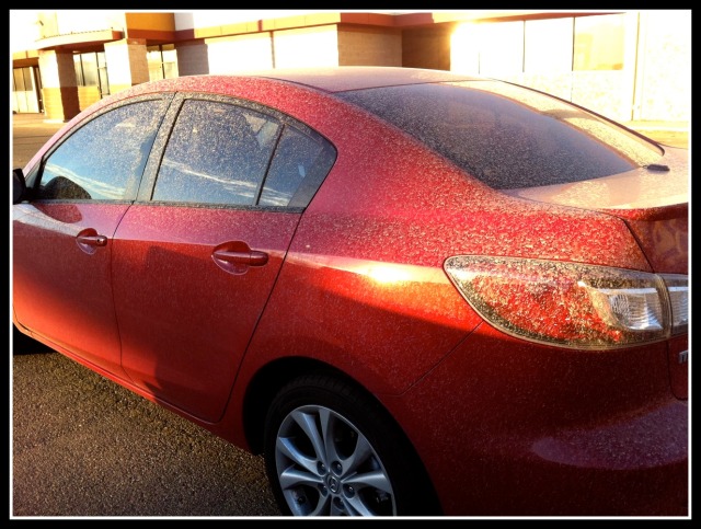
                                            What is dirty rain???????

If it had a red tint to it, it was most likely from the dust/dirt that originated in the central Plains States (i.e. OK, KS etc…). Many reports of blowing dust were received out across this area when this big storm system was moving through.  We believe one of two this happened here.  The updrafts (rapidly rising air currents) that gave birth to the thunderstorms carried this dust high into the atmosphere and up to jet stream level. As the storms continued east into our region that dust was being washed out of the atmosphere by the heavy rainfall that accompanied the storms.
Another possible reason could have been the tornadoes that accompanied yesterday morning’s storms.  It appears one very intense thunderstorm (embedded within the long line of storms that moved across all of area) was responsible for much of the damage that occurred. This embedded storm was what we call a supercell as it was long lived and produced a combination of straight-line wind damage and occasional tornadoes all along its path. That path was basically along and north I-64.  As most of you already know, a tornado is an intense rotating and rising column of air and forms in regions where there are both rapidly rising and descending air currents that are very close to one another. It’s very possible that the tornadoes that occasionally formed with this one supercell actually sucked up dirt and threw it high into the atmosphere – only to be washed out by the falling rain… hence “mud-rain”


I think that is crazy!!!!!! That was a car left sitting in Louisville while it was raining! I think that is a sign of the times! Have an awesome afternoon, and thanks for looking at the blog!

Wednesday, March 2, 2011

Awesome weather outside!!

Good afternoon! Thanks for looking at da blog! It is so nice out this afternoon with temps nearing 50. It will be extra cold tonight thanks to a cold front moving in. Lows will fall into the low 20s in some spots! Tomorrow will be an awesome day outside with everyone seeing 50s! Rain comes in Friday and it will be a wet, spring-like day. Highs will be in the mid 50s. Heavy rain will fall Friday night and all day Saturday. In all, 1-3" of rain is likely. Colder air moves in Sunday but we will rebound nicely early next week with sunshine.

Long Range Outlook:
The weather is expected to stay active over the next few weeks. While I expect things to really start warming with higher sun angle, there is still a lot of cold air up in Canada. This will gradually shoot our way after each system comes our way. I expect rain events with warmer temps, then brief cooldowns for a day or so after systems go by. It is all the shots of cooler weather that will shoot in from Canada, we have to get rid of it before "True Spring" happens. But it is looking like an average month temperature wise, and lots of rain, which can be expected as spring gets here. Thanks for looking at Nate's weather blog, have a good evening guys!

Nice weather before things get crazy!

Good morning. What an awesome weather day it was yesterday! Today will be another clear, sunny day with a cool front sliding through this morning. This may keep temps down a little, but should still hit the mid 40s in Indy, low 40s north, and upper 40s near 50 in the south. Tonight will get really cold with lows in the low-mid 20s. Temps will warm rapidly tomorrow with partly/mostly sunny skies and highs near 50 central, upper 40s north, and mid 50s south. Light rain will return Thursday and Friday. I think there will be quite a bit of dry weather on Friday with highs in the mid-upper 50s! Heavy rain will fall Friday night through Saturday evening. By Saturday evening. 1-3" of rain is likely. I wouldn't be surprised if there are isolated 4" amounts near Lafayette. This will cause LOTS of flooding with the already high river levels. Sunday through Tuesday of next week will be dry with low 40s Sunday and Monday with upper 40s by next Tuesday. Have an awesome day, and thanks for looking at Nate's weather blog!

Tuesday, March 1, 2011

Sunny Afternoon!!

Hey everyone! Just a quick afternoon update. It is a sunny, average, early March day. The average highs are in the upper 40s for early March. Right now temps are surging up in the mid 40s with sunny skies. We will add a few more degrees to that, reaching the predicted highs in the upper 40s. Today officially begins "Meteorological Spring"! :)

Sunny Start to March

Good Morning!! It's March!! It is a really cold morning because of dry air, clear skies, and light winds, with those in place, lows can really tank. That also means they rise quickly with lots of sunshine! Highs today will hit the upper 40s central, mid 40s north, and low 50s in southern Indiana. Tomorrow will be another sunny, awesome day with a high of 50 central, upper 40s north, and low-mid 50s south. Thursday highs will hit the low 50s central, near 50 north, and mid-upper 50s south. Rain will come in Thursday night through early Fiday. There could be a quick 25-.50  of rain through Friday afternoon. Heavy rain come Friday night through Saturday. 1-3" of rain is likely by Saturday night. Sunday will be cold with possibly some light snow! Thanks for looking at the blog. Have an awesome day!