Good evening. After some early wake-up call thunderstorms moved across southern Indiana early this morning, at least we had a dry day of weather in most of the state. One tornado was confirmed in Dubois county, near the town of Duff. VERY heavy rain of 2-4" in areas caused water to flood some roads this morning. In central Indiana, it was a much lighter rain that fell last night, with only a little thunder.
Scattered storms are still possible tonight, but probably not widespread. There is a good chance of storms on Monday, as a warm front lifts north, and a cold front moves in. Much hotter and sticky weather will be around tomorrow, with highs in the upper 80s. The best chance for those storms will be tomorrow afternoon, with most of the state under a slight risk for severe storms!
The rest of the forecast is simple from Tuesday on. Sunny skies and very nice summer days! Highs Tuesday and Wednesday will be between 80-85, with very low humidity! Lows may drop into the upper 50s Wednesday morning. More sunshine for the end of next week, as the heat and humidity are back for the big 4th of July weekend. Highs will be in the upper 80s Thursday, and 90 or better Friday. There is a slight chance of storms next Saturday, with temps in the upper 80s-near 90.
Thanks for checking the blog!

Sunday, June 26, 2011
Sunday, June 19, 2011
Storm chances continue-along with increasing heat!
Good Father's Day evening! Thanks for checking the blog! What a start to the day it was this morning! A squall line moved across southern Indiana, with damaging winds in excess of 60 mph and hail. Two tornados have been confirmed from this morning's storms just south of the river, in Breckinridge county, Ky.
How about those upper 80s and 90s I was predicting this weekend? Instead temperatures stayed in the 70s and 80s, thanks to clouds keeping things from heating up.
Storms stay in the forecast tonight, but not as widespread as last night. I will give about a 50% chance of storms across Indiana after midnight.
I have now added scattered storms in the forecast for tomorrow, given the humid and unstable atmosphere, with the warm front still hanging around. There will be plenty of dry time tomorrow, so don't cancel any plans. Highs will range from 85-90. Slight risk remains for severe storms!

Tuesday looks to be the hottest day of the week! We should see decent sunshine most of the day before scattered storms pop-up towards the afternoon/evening. Highs will range from 89-94, with heat indices nearing 100.
Wednesday looks like a wet and stormy day, with severe weather possible. Highs will be in the 80s.
Temps fall again towards the end of the week, with temperatures near 80 by Thursday, with scattered storms still possible. Isolated shower Friday, with highs in the upper 70s.
Next weekend looks nice for now, with really pleasant temps near 80! A frontal boundary looks to get caught somewhere in the lower Ohio Valley, so I wouldn't be so certain about dry weather next weekend, until confidence is higher. Should this front remain around Indiana? Then showers will be possible, but I will keep it dry for now. That is one active pattern!!!!
Back to the storm threat tonight and tomorrow.. here are radars to track any storms that form tonight and tomorrow:
Indiana:

Jasper:

Evansville:

Bloomington:

Indy metro:

Regional radar:

Have a great night! I will try to update again tomorrow, so check back! You can also follow me at twitter, for the latest weather updates on the side of the blog.
How about those upper 80s and 90s I was predicting this weekend? Instead temperatures stayed in the 70s and 80s, thanks to clouds keeping things from heating up.
Storms stay in the forecast tonight, but not as widespread as last night. I will give about a 50% chance of storms across Indiana after midnight.
I have now added scattered storms in the forecast for tomorrow, given the humid and unstable atmosphere, with the warm front still hanging around. There will be plenty of dry time tomorrow, so don't cancel any plans. Highs will range from 85-90. Slight risk remains for severe storms!
Tuesday looks to be the hottest day of the week! We should see decent sunshine most of the day before scattered storms pop-up towards the afternoon/evening. Highs will range from 89-94, with heat indices nearing 100.
Wednesday looks like a wet and stormy day, with severe weather possible. Highs will be in the 80s.
Temps fall again towards the end of the week, with temperatures near 80 by Thursday, with scattered storms still possible. Isolated shower Friday, with highs in the upper 70s.
Next weekend looks nice for now, with really pleasant temps near 80! A frontal boundary looks to get caught somewhere in the lower Ohio Valley, so I wouldn't be so certain about dry weather next weekend, until confidence is higher. Should this front remain around Indiana? Then showers will be possible, but I will keep it dry for now. That is one active pattern!!!!
Back to the storm threat tonight and tomorrow.. here are radars to track any storms that form tonight and tomorrow:
Indiana:
Jasper:
Evansville:
Bloomington:
Indy metro:
Regional radar:
Have a great night! I will try to update again tomorrow, so check back! You can also follow me at twitter, for the latest weather updates on the side of the blog.
Wednesday, June 15, 2011
Scattered storms this evening-Heat and Humidity by the weekend!
Good evening! There are scattered strong storms across southwest Indiana, and you can track those by clicking "radar" at the top of the page. Temperatures continue to stay cool, near 70 degrees.
Skies will clear tonight, and some patchy fog is possible by morning. Temps will drop in the low 60s.
Lots of sunshine is in the forecast tomorrow, with temps back in the low 80s. It will be breezy as well. There is about a 20% chance of a stray storm north of I-70 tomorrow afternoon.
A better chance of pop-up storms is expected Friday-Sunday, with heat and humidity making a big comeback! Mid 80s Friday, upper 80s Saturday, low 90s by Sunday. There will still be plenty of dry hours.
Next week will start HOT, with temps on Monday around 93, with sunshine and high humidity. Heat index will be back near 100 degrees late Monday. Scattered storms return next Tuesday and Wednesday, with low 90s next Tuesday, cooling back to about 86 by next Wednesday, in central Indiana.
Thanks for checking the blog! You can also check the blog on your phone, because I now have a mobile version of the blog.
Tuesday, June 14, 2011
Monday, June 13, 2011
Beautiful evening-tracking midweek storm chances
Good evening! I hope everyone spent their day outside i
Sunday, June 12, 2011
Cooler weather to stay for a while!
Good Sunday afternoon! I hope everyone is spending their day outdoors in this great weather! Low humidity, sunshine, and temps in the low-mid 70s! After 2 weeks of 90s and humidity, this is just what we needed!
Tonight will be plain chilly for June, with lows in the low-mid 50s! Open your windows!
Tomorrow will be another beautiful one, with most of the state staying in the 70s. Skies will be partly sunny for most, with more clouds in the southwest parts of the state.
Tuesday-Thursday can expect rounds of storms and heavy rain moving from the northwest to the southeast across the state. Highs will be in the upper 70s Tuesday, then low 80s Wednesday and Thursday. I am not expecting washouts, but rain is certainly possible.
More showers and storms are possible through next weekend, with temps warming near average, in the mid 80s.
This type of pattern can put down some heavy rain. We could use the rain, as things have really dried out with all the heat and lack of rain lately. Check out the GFS rain potential Tuesday-Thursday:

Have a great evening, and enjoy this nice weather!
Tonight will be plain chilly for June, with lows in the low-mid 50s! Open your windows!
Tomorrow will be another beautiful one, with most of the state staying in the 70s. Skies will be partly sunny for most, with more clouds in the southwest parts of the state.
Tuesday-Thursday can expect rounds of storms and heavy rain moving from the northwest to the southeast across the state. Highs will be in the upper 70s Tuesday, then low 80s Wednesday and Thursday. I am not expecting washouts, but rain is certainly possible.
More showers and storms are possible through next weekend, with temps warming near average, in the mid 80s.
This type of pattern can put down some heavy rain. We could use the rain, as things have really dried out with all the heat and lack of rain lately. Check out the GFS rain potential Tuesday-Thursday:
Have a great evening, and enjoy this nice weather!
Wednesday, June 8, 2011
Heat and Humidity
Good afternoon! I hope everybody is keeping cool on this HOT afternoon. Temps are in the low-mid 90s, with heat indices in the upper 90s in areas! It would all be fine with me, except living in a house with no central air, it is hard to keep things cool! This month so far has been WAY above normal with temps, but there are storms in the forecast that will bring relief over the next few days.
-Hazy and humid night, with isolated storms in northwest Indiana around daybreak. Lows will only drop in the 70s.
-Sunshine will be around tomorrow morning, then we will watch the skies tomorrow afternoon for scattered severe storms. Hail and damaging winds are the main threats, along with torrential rains. The humidity will be sky high tomorrow, with temps in the upper 80s-low 90s.
-Friday will be another partly sunny day with scattered storms. Most of the day should be dry, but storms could fire at any time. Heat and humidity will stick around, with highs in the upper 80s.
-The weekend doesn't look like a washout. There is a decent shot of scattered storms on Saturday, with cooler temps in the low 80s central and north, with mid-upper 80s south. I wouldn't rule out severe storms, along with areas of flash flooding. Sunday looks awesome, as we FINALLY kick out that humidity! Highs will range from the mid-upper 70s in northern Indiana, around 80 central, and low-mid 80s in southern Indiana. It will be a comfortable day!
-Slightly warmer and humid air returns early next week, along with chances of isolated-scattered storms. No washouts expected any day, with temps warming back in the mid 80s. Still much cooler than this week!
Stay cool, and have a great evening!
Saturday, June 4, 2011
Severe storms racing south!
Good evening! There has been a line of storms that has drifted from northern Indiana, and is currently moving through Indianapolis. Heavy rain, gusty winds, hail, and torrential rains have been threats with this line. In southern Indiana, it is hot and dry. These storms now look to move into Bloomington within the next hour, then across the southern half of Indiana later tonight. Be sure to bring anything in that may blow away from the storm. These storms will near the Vincennes, Bedford, Seymour areas within the next 2 hours or so. I am not too confident how much these will hold together, but storms certainly possible anywhere, mainly across central and southern Indiana tonight. Here are radars to track these intense storms:

Storm tracks:


Be sure to follow me on twitter for the latest weather updates, also on the sidebar of the blog. Have a good evening! Stay safe!
Storm tracks:
Be sure to follow me on twitter for the latest weather updates, also on the sidebar of the blog. Have a good evening! Stay safe!
Dangerous Heat-tracking storms
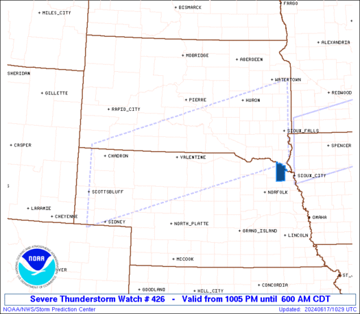
Good afternoon. Today has been the hottest day of the year so far, with temps in the mid 90s, along with heat indices at or above 100! When it's this hot and humid, it is easy for storms to get started. A severe t'storm watch is in effect for northern Indiana. Here is the watch box #426:
Isolated storms are starting to pop in northern Indiana, and will continue through the evening. The best chance of storms through the evening will be north of Indianapolis. I think southern Indiana stays dry until tomorrow, as the front moves closer. Here are radars to track the storms:


Also, follow me on twitter! If anything turns severe, I will update on twitter, and you can read my tweets on the side of the blog. Have a great evening!

Isolated storms are starting to pop in northern Indiana, and will continue through the evening. The best chance of storms through the evening will be north of Indianapolis. I think southern Indiana stays dry until tomorrow, as the front moves closer. Here are radars to track the storms:
Also, follow me on twitter! If anything turns severe, I will update on twitter, and you can read my tweets on the side of the blog. Have a great evening!
Hot and Humid Weather Pattern
Good Saturday! We are starting the weekend on a hot note! The humidity will be increasing as well, with "feel-like" temps in the mid-upper 90s! Strong storms will also be possible as a front moves in, mainly this evening and tonight.
Sunday will be slightly cooler, with mid-upper 80s. Skies will be partly sunny with pop-up storms tomorrow afternoon. Don't cancel any outdoor plans!
The pattern next week will be very hot and muggy around here! Isolated storms are possible Monday, then again later Thursday. Other than that, sunshine and hot temps! Temps will go from upper 80s Monday, near 90 or better Tuesday-Thursday, then mid-upper 80s by next weekend.
There is some MAJOR heat going on in the mid south, and all of the south! In Memphis, TN, for example, the NWS is forecasting a high of 100 today, with heat indices around 108-110! They can expect more of that throughout next week!! Now that is a heat wave! The Ohio Valley remains on the edge of the heat ridge, but this is still keeping our temps well above average. There are signs of the pattern shifting a bit towards the middle-end of June, with an active and cooler pattern possible by the end of the month, and especially towards July. Right now, July and August look below average, with above average precip. Areas in the southern plains and south look to stay in a dry and hot pattern through the summer months!
Thanks for checking the blog, have a great weekend!
Friday, June 3, 2011
A nice afternoon!
Good afternoon. Isn't the weather great outside? Sunny skies right now with low humidity, along with a gentle breeze making for a great afternoon! If you have outdoor plans this evening, the weather will be perfect! Temps will go from the 80s now to the mid-upper 70s later in the evening. I will update later on tomorrow's hot weather. Get outside and enjoy this weather!!
More heat and humidity on the way!
Good morning! Thanks for checking the blog. We have enjoyed a nice break from the heat and humidity, but it looks to move back in and in no hurry to leave!
Scattered showers are possible through noon today, then skies will become partly sunny. The humidity should stay in the comfortable range, with highs in the mid 80s.
The heat and humidity will be back tomorrow! Highs will hit the low 90s, with a heat index in the upper 90s! Take it easy, and stay hydrated! Southern parts of the state will see heat indices near 100! Because of the heat, scattered storms are possible tomorrow afternoon. A few could be severe. If you have outdoor plans tomorrow, don't cancel them! These storms will be rather isolated, and we will see sunshine for the better part of the day.
Slightly cooler for Sunday, with a mix of sun and clouds, and a small storm chance. Highs will hit the upper 80s.
The pattern for next week continues to look very summer-like, with highs in the upper 80s and low 90s. The humidity will stick around as well. Isolated storms will be possible later Wednesday-Friday, with many places staying dry. The pool will be the place to be next week!!
Have a great day!
-Nate
Subscribe to:
Posts (Atom)