Stay tuned to my facebook weather page for updates.. http://www.facebook.com/Nathanlovesweather4

Monday, April 30, 2012
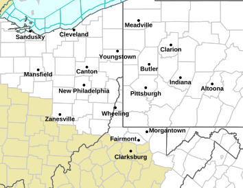
SEVERE THUNDERSTORM WATCH
Stay tuned to my facebook weather page for updates.. http://www.facebook.com/Nathanlovesweather4
Latest on Severe Weather Threat This Evening - 90 degree Heat Possible Later This Week!
As is often the case during summer, we have a chance of thunderstorms, especially later this evening, and again tomorrow afternoon. I want to "emphasize" that there will be much more dry weather than wet, and a few days later this week may stay completely dry, with hot weather taking over. Someone will hit 90 degrees before the week is done.
Severe weather possible later today, through the evening: Pretty nice out so far. The only rain and thunder on radar is in northern Indiana, with the rest of the area dealing with warm temps and a tropical like air mass. However, the atmosphere is becoming unstable, and there is a decent chances of a strong line of thunderstorms this evening. The SPC has already said that a watch may be needed for the circled are from about north-central Indiana southward:

The timeline for severe storms looks to be 4pm-8pm. My facebook page is the place to go when severe weather is pending. Here is the link to go "like" my page: http://www.facebook.com/Nathanlovesweather4
Tuesday will be another warm, sticky day outside, along with another chance for storms. It will not be a washout of a day, with the best chance of storms once again during the afternoon and evening. There is not officially a severe weather risk yet, but that could change. They did issue a statement for the Ohio Valley tomorrow.... ...MID MS/LOWER OHIO VALLEY INTO THE MID ATLANTIC STATES...
   ONE OR TWO SHORT WAVE IMPULSES EMBEDDED WITHIN 30-40+ KT WESTERLY
   MID-LEVEL FLOW COULD HELP FOCUS AREAS WITH AT LEAST A LOCALIZED
   STRONG/SEVERE STORM THREAT ON TUESDAY.  HOWEVER...CONSIDERABLE
   UNCERTAINTY REMAINS...DUE IN PART TO THE TENDENCY FOR AT LEAST WEAK
   LARGER-SCALE MID-LEVEL HEIGHT RISES...AND EARLY DAY CONVECTIVE CLOUD
   COVER WHICH MAY STRONGLY RESTRICT BOUNDARY LAYER DESTABILIZATION.
For Wednesday-Friday, any storms will be very isolated, with some areas staying completely dry all together. With more sunshine, temperatures will be downright hot. Temps these days will range between 85-90, and heat indices could reach the lower 90's. Yup, welcome to summer! :)

The warm temps should hang on for the weekend, but storm chances will gradually go up.
STORMS DEVELOPING ON RADAR: Before I go, I want to give you a radar update. As of 2:30, a line of showers and storms across east-central Illinois appears to be getting a bit more intense as it moves towards Indiana. A few cells have also just popped up near Terre Haute and Lafayette. It could be a stormy evening, so stay tuned to facebook! Here is a look at radar....

STORMS DEVELOPING ON RADAR: Before I go, I want to give you a radar update. As of 2:30, a line of showers and storms across east-central Illinois appears to be getting a bit more intense as it moves towards Indiana. A few cells have also just popped up near Terre Haute and Lafayette. It could be a stormy evening, so stay tuned to facebook! Here is a look at radar....
Stay tuned, and have a great rest of your day.
Storms Kick Off A Hot Week!
Good morning! As your stepping out the door this morning, you have already noticed the warmer air outside this morning! Current temps are in the upper 50's and low 60's. Most areas are starting off dry, but it will be a different story later today.
A warm front will be lifting north of the area today, with a warm, humid, unstable atmosphere through the afternoon and evening. The best chance for storms will be from 3pm-10pm, with some being severe. The SPC has placed the area under a slight risk for severe storms.

Tomorrow will be another warm/muggy day, with a chance of storms, some which could turn severe. Not a washout of a day, but storms could be around at almost anytime.
Wednesday and Thursday will be HOT & HUMID! These days will feature the smallest risk of storms, with more in the way of sunshine. Highs will easily hit the middle to upper 80's, with an isolated spot touching 90 degrees. #LOVEIT
Storm chances will gradually go up again later Friday and Saturday, with warm temps remaining. The Mini Marathon in Indy is Saturday morning, and right now, it looks to be a very warm and humid for the runners. Storms are possible, but let's hope they stay away!
There you go, if you love a week filled with summer temperatures, this will be your week! There will be plenty of dry weather as well to get outside, just check radar before you head out!
Have a great Monday!
A warm front will be lifting north of the area today, with a warm, humid, unstable atmosphere through the afternoon and evening. The best chance for storms will be from 3pm-10pm, with some being severe. The SPC has placed the area under a slight risk for severe storms.
Tomorrow will be another warm/muggy day, with a chance of storms, some which could turn severe. Not a washout of a day, but storms could be around at almost anytime.
Wednesday and Thursday will be HOT & HUMID! These days will feature the smallest risk of storms, with more in the way of sunshine. Highs will easily hit the middle to upper 80's, with an isolated spot touching 90 degrees. #LOVEIT
Storm chances will gradually go up again later Friday and Saturday, with warm temps remaining. The Mini Marathon in Indy is Saturday morning, and right now, it looks to be a very warm and humid for the runners. Storms are possible, but let's hope they stay away!
There you go, if you love a week filled with summer temperatures, this will be your week! There will be plenty of dry weather as well to get outside, just check radar before you head out!
Have a great Monday!
Sunday, April 29, 2012
80's THIS WEEK!! - HOW ABOUT STORM CHANCES?
We have been waiting and waiting for some warm weather to actually "stay" for a while, and it finally will this week. In fact, you will be hearing the words "hot and humid" before the week is done.
We do have storm chances, and what I love about the blog is that I can go into detail in timing the best chance of getting storms. This week will not be a washout, and the best storm chances will be mainly early in the week. Let's get to the forecast..

Tuesday: A warm/muggy day across Indiana, along with more storms, with the highest threat during the afternoon. Highs will be near 80 again. The GFS does show a good deal of shower and thunderstorm activity Tuesday...


Things look to stay pretty warm right through next weekend! Yup, May will have a very, very warm start this year! Thanks for stopping by the blog, have a great night.
Saturday, April 28, 2012
DAMAGING HAIL IN SOUTHERN INDIANA - MORE STORMS ON THEIR WAY!
Good evening. Insane weather day in Indiana, with an incredible clash of air masses. In southern Indiana, temperatures today soared in the lower 80's - with a quick spike in the humidity. In Indianapolis, it struggled to pass 50! Farther north - stuck in the 40's today. Severe storms have developed on the edge of the warm/cold air, and many areas in southern Indiana have seen a horrifying hail storm this evening, with some car damages being reported.
Let me start by saying my drive home from dinner was horrible. Nothing worse than getting caught in baseball size hail and 50 mph winds! It felt like someone constantly throwing 100 baseballs a second at the car - NO KIDDING! Good news - the car had no damage, and I think that had to be God! I even recorded some of the scary moments on the drive home, and I will upload that video on facebook here in a bit. Check out these hail pics from the French Lick area....

TONIGHT'S OUTLOOK: Unfortunately, there are more showers & storms across the state line, and those will continue to move through southern Indiana overnight. The good news is that these storms appear to be weakening, but a few more warnings can't be ruled out. Flooding will also be a concern in areas that have already got torrential rains this evening. The tornado watch and severe thunderstorm watch remains in effect until 11pm. Here is a map of the latest watches/warnings, along with radars to track these storms...


I apologize for not keeping facebook updated earlier, as I was not able to update the warnings. If any new warnings are passed along, I will let you know. Have a great night.
Let me start by saying my drive home from dinner was horrible. Nothing worse than getting caught in baseball size hail and 50 mph winds! It felt like someone constantly throwing 100 baseballs a second at the car - NO KIDDING! Good news - the car had no damage, and I think that had to be God! I even recorded some of the scary moments on the drive home, and I will upload that video on facebook here in a bit. Check out these hail pics from the French Lick area....

I apologize for not keeping facebook updated earlier, as I was not able to update the warnings. If any new warnings are passed along, I will let you know. Have a great night.
Friday, April 27, 2012
One Year Ago Today
One year ago today, a major tornado outbreak devastated many southeastern U.S. cities, and claimed the lives of 321 people. Check out this article from Accuweather.......
 Do you have photos of the damage you'd like to share? Or photos that honor the tornado victims and clean-up volunteers? Tweet them to @AccuWeather.
It's been a year since the Super Outbreak of 2011. April 2011 is ranked as the most active tornado month on record with 758 tornadoes. The National Weather Service confirmed 358 tornadoes from April 25 to 28, 2011. The previous record for April tornadoes was set in April 1974 with 267 tornadoes.
National Weather Service records show that 321 people died during the four days of the outbreak. March 18, 1925, holds the record for the most tornado-related deaths with 747 people killed. Out of those 747 deaths in 1925, 695 people were killed from the lone Tri-State Tornado. The Tuesday night into Wednesday part of the outbreak was the deadliest two-day period since April 5-6, 1936, when 454 people were killed.
Do you have photos of the damage you'd like to share? Or photos that honor the tornado victims and clean-up volunteers? Tweet them to @AccuWeather.Difficult Saturday Forecast - Warm Next Week!
Happy weekend everyone! :) Here are your blog highlights:
-Rain returns with a stalled out front tonight/Saturday.
-Huge temp spread tomorrow - 40s and 70s.
-Severe storms poss. in southern Indiana Saturday.
-70's and 80's likely next week/ active pattern!!
Here we go....
TONIGHT: After the front moved south last night, it's on it's way NORTH again tonight and tomorrow. Rain chances will arrive after 3am.

SATURDAY: As the front tries to move north, it will put the brakes on somewhere in central Indiana. Where is stalls is key to temperatures and rain chances. If I were to put a stab into it, I think the front stalls out across south-central Indiana. North of the front - cold and wet. South of the front - warm, humid, severe storm risk. Indianapolis looks to stay on the cold side, (50's) while areas south of Bloomington and Columbus make a run at 70+. As far as rain chances, it looks like the best chances of rain will be north of I-70 during the afternoon, with plenty of breaks in the rain across southern Indiana. Southern Indiana may see brief sunshine before severe storms develop. Here is the GFS:

SUNDAY: The front will still remain nearby, but it appears that rain chances will be much lower. Just more isolated showers for Sunday, with most areas in the lower 60's.
 SEVERE WEATHER? The SPC has highlighted extreme southern Indiana (south of Vincennes/Bedford/North Vernon) under a slight risk for severe weather tomorrow afternoon and evening. This WILL need to be monitored for any northward shifts in the risk. The best chance for some severe storms looks to be mid-afternoon-early evening.
WARM AND WET NEXT WEEK: The front that will plague the area this weekend will finally lift way north of us! This opens the door to very warm temperatures, and gulf moisture. Several disturbances will be moving through, bringing a daily chance of thunderstorms. This set-up can bring slow moving thunderstorms, that can cause copious amounts of rain in isolated areas. (Something to watch). Despite that, NO washouts are expected, and there should be several dry hours each day to enjoy the warm temperatures. How warm will it get? Temps on Monday will range from 65-80, (due to a front lifting northward) then 73-81 Tuesday, then low-mid 80's Wednesday and Thursday - high humidity will make it fell summer-like.
Have a terrific weekend!
-Rain returns with a stalled out front tonight/Saturday.
-Huge temp spread tomorrow - 40s and 70s.
-Severe storms poss. in southern Indiana Saturday.
-70's and 80's likely next week/ active pattern!!
Here we go....
TONIGHT: After the front moved south last night, it's on it's way NORTH again tonight and tomorrow. Rain chances will arrive after 3am.

SATURDAY: As the front tries to move north, it will put the brakes on somewhere in central Indiana. Where is stalls is key to temperatures and rain chances. If I were to put a stab into it, I think the front stalls out across south-central Indiana. North of the front - cold and wet. South of the front - warm, humid, severe storm risk. Indianapolis looks to stay on the cold side, (50's) while areas south of Bloomington and Columbus make a run at 70+. As far as rain chances, it looks like the best chances of rain will be north of I-70 during the afternoon, with plenty of breaks in the rain across southern Indiana. Southern Indiana may see brief sunshine before severe storms develop. Here is the GFS:

SUNDAY: The front will still remain nearby, but it appears that rain chances will be much lower. Just more isolated showers for Sunday, with most areas in the lower 60's.
SEVERE WEATHER? The SPC has highlighted extreme southern Indiana (south of Vincennes/Bedford/North Vernon) under a slight risk for severe weather tomorrow afternoon and evening. This WILL need to be monitored for any northward shifts in the risk. The best chance for some severe storms looks to be mid-afternoon-early evening.WARM AND WET NEXT WEEK: The front that will plague the area this weekend will finally lift way north of us! This opens the door to very warm temperatures, and gulf moisture. Several disturbances will be moving through, bringing a daily chance of thunderstorms. This set-up can bring slow moving thunderstorms, that can cause copious amounts of rain in isolated areas. (Something to watch). Despite that, NO washouts are expected, and there should be several dry hours each day to enjoy the warm temperatures. How warm will it get? Temps on Monday will range from 65-80, (due to a front lifting northward) then 73-81 Tuesday, then low-mid 80's Wednesday and Thursday - high humidity will make it fell summer-like.
Have a terrific weekend!
Thursday, April 26, 2012
Dry For Now - Rain Returns - Big Temp Spread Saturday!
Friday doesn't look too bad, but it will be below normal for late April. Highs tomorrow will be mainly in the 50's, with a few 60's south of Bloomington and Columbus. Skies should be partly sunny, with more clouds towards evening. ALSO - a hard freeze watch has been issues for northern Indiana tonight - cover up those plants!!
This leads us to another wet period overnight Friday through Saturday night. The temperature spread for Saturday is truly amazing. GET THIS - northern Indiana will be in the upper 30s for HIGHS Saturday, with sleet mixing in with rain possible. Temps in far southwest Indiana should be in the upper 70's. Check out these wild numbers from the GFS...

Yes, near 80 and barely above freezing all in the same state! Near 50 degree temp difference! Is that insane or what? So what kind of temperatures can you expect Saturday? It depends on where you live. Temperatures across central Indiana could see the biggest gradient, with Muncie and Peru barely in the middle 40's, with areas near Terre Haute, Bloomington, and southwestward seeing much milder air. Indianapolis looks to stay on the chilly side, with highs in the mid 50's, with rain around. These numbers will change a but depending on where this front stalls.
There is some good news for the second half of the weekend, as some sun returns for the Sunday forecast. Temperatures will actually be decent, in the lower to middle 60's.
It continues to look like a major warm-up next week. 70's return Monday, with upper 70-lower 80's for the rest of the week. However, an active pattern looks likely as well. Rain chances EVERY day, but they will like a summer, pop-up variety. This means a humid, tropical-like air mass!
Have a great rest of your day!
Wednesday, April 25, 2012
Severe Storm Risk - Tracking More Rain Chances!
The SPC has now included basically all of Indiana in the "heart" of the severe weather risk. Here's the set-up. The clash of two air masses! We have a huge heat ridge to our west (80s/90s) and cool air hanging on just off to the northeast.

The severe weather risk goes up through the evening, mainly 7pm-2am. MAIN THREATS are damaging winds and large hail. My facebook page will keep you posted with the latest warnings, so if you haven't "liked" it yet, click "facebook page" at the top, and go "like" my page!
Most areas dry out tomorrow, with partly sunny skies. Highs tomorrow will remain steady, mainly in the 60's. All in all, a decent day!
For Friday and the weekend, that same front lifts BACK north again.. and guess what that means> more rain! However, as the front lifts close to the Ohio River, it will stall out, leaving most of Indiana downright chilly. Rain chances will ramp up late Friday, especially south of I-70, with highs in the 50's. For Saturday, much of the state will be stuck in the 50's, with 40's for HIGHS Saturday north of I-70!!! Add rainfall to that, and you've got one miserable Saturday forecast! The state finally dries out for Sunday, but a chill will remain.. yup, another chilly and not-so-nice weekend ahead. How much rain expected? Between now and early Sunday, we could see as much as 1-2" of rain.
For Friday and the weekend, that same front lifts BACK north again.. and guess what that means> more rain! However, as the front lifts close to the Ohio River, it will stall out, leaving most of Indiana downright chilly. Rain chances will ramp up late Friday, especially south of I-70, with highs in the 50's. For Saturday, much of the state will be stuck in the 50's, with 40's for HIGHS Saturday north of I-70!!! Add rainfall to that, and you've got one miserable Saturday forecast! The state finally dries out for Sunday, but a chill will remain.. yup, another chilly and not-so-nice weekend ahead. How much rain expected? Between now and early Sunday, we could see as much as 1-2" of rain.

"TRUE" SPRING FILLS U.S. NEXT WEEK: Models continue to show much of the country getting out of this extreme pattern, with all these wild temp swings. In fact, a good chunk of the country may turn above normal Tuesday and beyond. The models are in good agreement of a big warm-up next week, and this one looks to have staying power! This means 70's by next Tuesday, perhaps an 80 for the latter part of next week. Looking BEYOND next week, in the time-frame from May 3rd-May 9th, it looks to be very warm, perhaps a bit like summer around here! :) Check out the 8-14 day outlook:

I'M SO READY!! Here in a few short weeks, I will begin to get the pool ready for summer. Speaking of summer, I am going to do some research over the next few days, and make my OWN summer outlook. It may surprise you, and no, I'm not going to copy other people's opinions. I will be looking more into our fading La Nina, which may turn into an weak El Nino, pacific ocean temps, and many other factors when making a long-range forecast. That summer outlook will be revealed on the blog next Wednesday, May 2nd!
Have a great rest of your evening, and don't forget about our severe weather risk this evening. My facebook weather page will have updates as needed.
Have a great rest of your evening, and don't forget about our severe weather risk this evening. My facebook weather page will have updates as needed.
Tuesday, April 24, 2012
NICE AFTERNOON - PLENTY OF RAIN CHANCES - UP & DOWN TEMPS!
Good afternoon, everyone! Hope your having a great day so far! It feels better out than yesterday. We have sunshine in place, and much, much lighter winds. It actually feels pretty pleasant if your out in the sun.
How about some baseball tonight? The Indians take on the Louisville Bats. Temperatures should be around 60 at first pitch.

A warm front will lift through the state later tomorrow, resulting in a "brief" warm-up. BUT... 50's for highs return again by Friday. Yup, our roller coaster ride in temps continue..

It's also a very active pattern. Showers and storms will become likely tomorrow evening, with a few severe storms possible south of I-70. We will have at least a chance of a couple showers Thursday and Friday as well.
The weekend looks to be very chilly and damp over much of the area, with MORE rain chances. Why in the world do we seem to always have the WORST weather come for the weekends. We need to shake this pattern!!
Warm-Up by May? It appears we may FINALLY get out of this annoying, blocked up pattern by the middle of next week, as warmer air moves over much of the U.S. Check out this 8-14 day outlook, indicating above normal temps, 70's and 80's by May 1-7. (This may get pushed back further, but here is hoping).
More weather updates on facebook, as needed. Have a great rest of your day!
Monday, April 23, 2012
Tracking A Warm Up Mid-Week - Rain Chances
Good evening. Today turned out to be a nice, sunny day across the Hoosier state. Despite that sunshine, it felt quite cool out. We have a strong northerly flow across the Ohio Valley, due to a huge nor'easter not too far from here. It is SNOWING right now in western PA and western NY, and some areas have already picked up more than a foot. Think about it. That sure isn't too far from home. Check out The Weather Channel's Eric Fisher out in Somerset, PA, where they have picked up at least 6" of the white stuff so far...

A LOOK AHEAD......

It's not everyday that you see snow falling on top of green leaves!! Don't worry, snow is NOT in our forecast. Instead, we get to track warmer air on the way.
A LOOK AHEAD......
First off, we have another chilly night coming. Patchy frost is possible, but winds should stay up enough to limit any widespread frost. Still, prepare for temps in the 30's as you step out in the morning.
A mix of sun and clouds will be with us tomorrow. A weak disturbance *may* spark a shower or two, but the majority of the area can expect a decent day. It will be a bit milder, with temps ranging from 60-65 in most spots. This is still below normal. Winds will be much, much lighter, with just a gentle breeze.
On Wednesday, a warm front will be lifting northward, with MUCH warmer air gradually moving in. This means a huge temp swing from north to south. South of the front, 80 degrees is possible, and north of the front, struggling to reach 60. I think Indianapolis will pass the 70 degree mark, with southern Indiana well in the 70's, with northern Indiana staying MUCH cooler, mainly in the 60's. Here is the surface map for later Wednesday, the red line indicates the warm front.

While there is a chance of a few storms later Wednesday, the majority of the rain looks to arrive Wednesday night into Thursday. It looks to be in a MCS fashion, a.k.a (Mesoscale Convective System). The southern half of Indiana could see an inch or so of rainfall from this system!
Showers may hold on a bit on Thursday, especially from I-70 southward. Temps may hit 70 or better if you go south of Indy, but areas across northern Indiana will be much cooler. The majority of the area looks to stay dry Friday, with some cool air around.
For the weekend, it's looking very wild and active. A front may stall out across central Indiana, with periods of showers and storms. There may also be a huge temper
ature gradient across the state. If the GFS verifies, southern Indiana will flirt with 80 Saturday, with northern Indiana struggling to reach 50!!! Obviously, this forecast is just too low of confidence to really put into detail, so stay tuned.
Have a great night, everyone!
Sunday, April 22, 2012
A "WOW" Weather Pattern!
The blog is back!!!! :) It has been a bit since I have been on the blog, but I am back to updating again!
Anyway, the word WOW is a good way to sum up our weather pattern. Extreme heat out west, and a late spring WINTER STORM that will take place in places not too far from home. I think it is safe to say extreme has become the new normal around here. Never know what to expect anymore! It was near 80 a few days ago, and yesterday, we struggled to get out of the 40's. Let's see, will it be shorts or winter coats?
Let's talk about this unbelievable, crippling snowstorm that will take place to our east, as close as eastern Ohio!! I have seen late-season snows in far New England, but this far southwest is quite rare for it being almost May. Even more UNBELIEVABLE, this will be the BIGGEST SNOW of the WINTER in LATE APRIL for MANY parts of Pennsylvania, New York, and West Virginia. Check out all these winter storm warnings, watches, and advisories...
How about totals? Pittsburgh will be getting 2-4", with areas in the pink seeing 6"+! In fact, the latest NAM has up to 30" in the highest elevations of West Virginia. Temperatures will be right around freezing, or slightly above when the snow falls, so it will be a wet, sloppy snow. Areas that get 4" or more need to be prepared for power outages and widespread tree damage. Keep in mind, these trees have LEAVES on them, so just imagine piling up that much snow on them? Yep, it's going to be a mess.
HOW ABOUT INDIANA? You can breathe, now! :) No snow for us, but we will feel the storm's effects with the chilly air wrapping in on the western side of the storm. This also means very gusty winds for tomorrow and Tuesday. Even with sunshine around, highs tomorrow will be in the middle 50's, and the wind will make it feel like 40's. A little warmer on Tuesday, but still windy.
How about frost? A FREEZE WATCH has been posted for much of the state from 4am to 8am Monday morning. Temperatures will be near freezing, so COVER those plants! I almost lost my hydrangea shrub during the last freeze, so don't take a chance.
The next chance of rain arrives Wednesday into Thursday, with slightly milder air.
Behind that system? More chilly air. By next weekend, a front could stall out across the state, which already has me worried about a heavy rain threat, along with a HUGE temperature gradient. I have seen these type of set-ups bring 80's to Kentucky, and 50's in Indiana. Check out the GFS temps for next weekend:
 Our extreme weather pattern continues. Have a great rest of your day!
Anyway, the word WOW is a good way to sum up our weather pattern. Extreme heat out west, and a late spring WINTER STORM that will take place in places not too far from home. I think it is safe to say extreme has become the new normal around here. Never know what to expect anymore! It was near 80 a few days ago, and yesterday, we struggled to get out of the 40's. Let's see, will it be shorts or winter coats?
Let's talk about this unbelievable, crippling snowstorm that will take place to our east, as close as eastern Ohio!! I have seen late-season snows in far New England, but this far southwest is quite rare for it being almost May. Even more UNBELIEVABLE, this will be the BIGGEST SNOW of the WINTER in LATE APRIL for MANY parts of Pennsylvania, New York, and West Virginia. Check out all these winter storm warnings, watches, and advisories...
How about totals? Pittsburgh will be getting 2-4", with areas in the pink seeing 6"+! In fact, the latest NAM has up to 30" in the highest elevations of West Virginia. Temperatures will be right around freezing, or slightly above when the snow falls, so it will be a wet, sloppy snow. Areas that get 4" or more need to be prepared for power outages and widespread tree damage. Keep in mind, these trees have LEAVES on them, so just imagine piling up that much snow on them? Yep, it's going to be a mess.
HOW ABOUT INDIANA? You can breathe, now! :) No snow for us, but we will feel the storm's effects with the chilly air wrapping in on the western side of the storm. This also means very gusty winds for tomorrow and Tuesday. Even with sunshine around, highs tomorrow will be in the middle 50's, and the wind will make it feel like 40's. A little warmer on Tuesday, but still windy.
How about frost? A FREEZE WATCH has been posted for much of the state from 4am to 8am Monday morning. Temperatures will be near freezing, so COVER those plants! I almost lost my hydrangea shrub during the last freeze, so don't take a chance.
The next chance of rain arrives Wednesday into Thursday, with slightly milder air.
Behind that system? More chilly air. By next weekend, a front could stall out across the state, which already has me worried about a heavy rain threat, along with a HUGE temperature gradient. I have seen these type of set-ups bring 80's to Kentucky, and 50's in Indiana. Check out the GFS temps for next weekend:
Tuesday, April 17, 2012
The Roller Coaster Ride Continues
Today was a pleasant spring day outside. Clouds kept our temps down a bit lower than expected, but lots of sunshine will be the rule tomorrow and Thursday. 70-72 tomorrow, then middle 70's on Thursday. Bottom line.... Enjoy!

For Friday through the weekend, the forecast is nothing short of difficult! A cold front will move towards the area Friday, but models have slowed down on the arrival of the front. This now means the best chance of rain will begin Friday afternoon, through Saturday. At the same time, a cut-off low pressure will spin around somewhere to our east. I can't stress enough, position is key as to if there will be rain around all weekend. First off, here is the GFS for later Sunday, you can see the cut-off low spinning across the southeast, with the flow around it bringing in chilly temps locally. This set-up will likely bring snow to parts of the Interior Northeast.

To get everything clear....
-Rain arrives from northwest to southeast Friday, with southeastern Indiana staying dry until after sunset. A big temperature spread can be expected, with 50's near Gary, low 70's in Indy, and 80 possible in southeast Indiana.
-The front will begin to push southeast Saturday, with dry weather for northern Indiana, a slight rain chance for Indy, and a good chance of rain Saturday in southern Indiana. Temperatures will be cooler, mainly in the upper 50's!!
-For Sunday, I can't rule out a shower in extreme southeast Indiana, but most of the area should be dry. Highs on Sunday will range from 55-60.
-After the weekend chill, a MAJOR warm-up is shown in the long-range charts for the middle and end of next week. We may be talking summer-level temps next Wednesday and beyond. Seems like our weather has been a wild roller coaster over the past month. I'm just ready for our temps to STAY put, instead of these wild swings of 80's one day.. then 50's the next. Seems crazy, but this is just a typical spring pattern in Indiana. It's all part of the changing seasons!
Thanks for stopping by the blog, have a great night!
Monday, April 16, 2012
Get Ready For More Ups and Downs in Temps Through the End of April!
A band of rain and thunder moving through the state this morning. Much of that will exit by mid-morning, with sunshine and WINDY conditions this afternoon.

The NWS has decided to issue a wind advisory for today, until 6pm. Winds could gust as high as 45 mph in spots today. It will make travel tough, and please anchor down any loose items in your yard, or they will blow far, far away! :)
The next couple days look like great spring weather to get outside. Mainly mid/upper 60's for tomorrow, then 70's are back by Wednesday, with sunshine around.
Changes gradually arrive later this week. A cold front will stall out over Indiana Thursday. This will provide a chance of a couple showers. A low pressure will ride along that front Friday, with widespread rain likely on Friday.
A big-time change is on the way this weekend. A cut-off low will develop to our east, with a cold, northerly flow across Indiana. I'm not totally ruling out the idea of snowflakes, as the GFS does the potential in this set-up:

You can breathe, now! :)
As far as temperatures, 50's look like a good bet, with some areas staying in the upper 40's. Can you say, YUCK!!!! I probably ruined your day with this weekend forecast, huh? I'll see what I can do! Mother Nature likes to change her mind a lot, so this forecast could change for better, or worse..! We'll have to wait and see.
Looking farther down the road, a big-time warm-up is likely by the middle and end of next week. 80's could even return.
Moral of the story, UP and DOWN for the rest of the month.
Have a great Monday everyone.
Saturday, April 14, 2012
Rain Moves Out - Summer-like Sunday!
Not the best of days outside today, but many areas saw some MUCH needed rains. Indy officially received 1.15", with pockets of 2" of rain today south of Indy.
While we had non-severe storms locally, it continues to be one insane tornado outbreak across the Plains. Check out this incredible shot of twin tornadoes from KWTV. Could you imagine standing in the path of those tornadoes? Scary to say the least!

Keep all of those affected in your thoughts and prayers. Now to the forecast....
TONIGHT:
The warm front will begin to shift north, taking rain chances with it. It will be breezy, warm, and muggy, with temperatures remaining steady. NO jackets needed in the morning.
 SUNDAY:
It's going to be wonderful outside. With sunny skies and gusty southwest winds, temps will skyrocket in the 80's!!! No raincoat tomorrow, just shorts and flip-flops. :)
MONDAY:
A cold front will move through the state later Sunday night, through Monday morning. A quick line of showers or storms will move through around daybreak Monday, then the afternoon will be dry, windy, and mild.

Cooler temps, around 61-64 for Tuesday, then upper 60's Wednesday, with 70+ by next Thursday. All three days look dry. I don't even want to mention Friday's forecast. I know that is Prom Night, and right now, the day looks like it could be quite stormy! This CAN and WILL change, but for now, it's not looking good.
 Next Saturday is "Thunder over Louisville". I know many people are watching the forecasts closely. RIGHT NOW, it looks like any rain chance would end early, with mainly dry and chilly weather for the afternoon. As far as temps, it looks like it may be a bit chilly. Currently, it looks like lower 60's for Louisville, but mainly 50's for Indiana. This WILL change, so keep checking back.
Thanks for stopping by, have a totally awesome rest of the weekend!
While we had non-severe storms locally, it continues to be one insane tornado outbreak across the Plains. Check out this incredible shot of twin tornadoes from KWTV. Could you imagine standing in the path of those tornadoes? Scary to say the least!
Keep all of those affected in your thoughts and prayers. Now to the forecast....
TONIGHT:
The warm front will begin to shift north, taking rain chances with it. It will be breezy, warm, and muggy, with temperatures remaining steady. NO jackets needed in the morning.
It's going to be wonderful outside. With sunny skies and gusty southwest winds, temps will skyrocket in the 80's!!! No raincoat tomorrow, just shorts and flip-flops. :)
MONDAY:
A cold front will move through the state later Sunday night, through Monday morning. A quick line of showers or storms will move through around daybreak Monday, then the afternoon will be dry, windy, and mild.

Cooler temps, around 61-64 for Tuesday, then upper 60's Wednesday, with 70+ by next Thursday. All three days look dry. I don't even want to mention Friday's forecast. I know that is Prom Night, and right now, the day looks like it could be quite stormy! This CAN and WILL change, but for now, it's not looking good.
Thanks for stopping by, have a totally awesome rest of the weekend!
Wet & Stormy Afternoon
Good afternoon. Not the best weather day outside! Right now, we have widespread showers and thunderstorms moving through. A line of storms and heavy downpours is moving right across the central part of Indiana, and continues to push east. A couple hours of moderate rain is likely, before it pushes east. There are also other storms popping up in eastern and southern Indiana. These areas can expect quick, heavy downpours, lightning, perhaps small hail as these move through. I do think there will be some dry hours later this afternoon for many areas. For the next 1-2 hours, you may want to hold off any outdoor plans. Here is the radar to track the thunderstorm activity....

Temperatures later today should top out in the middle 60's-lower 70's, depending on how much dry time we get.
We should dry out later tonight and tomorrow, as we get into the warm sector. Tomorrow looks to be mainly dry, with a mix of sun/clouds. It will be breezy and very warm, with highs near 80! Make those outdoor plans!
Have a great rest of your day.
We should dry out later tonight and tomorrow, as we get into the warm sector. Tomorrow looks to be mainly dry, with a mix of sun/clouds. It will be breezy and very warm, with highs near 80! Make those outdoor plans!
Have a great rest of your day.
Friday, April 13, 2012
Warmth Returns - Soggy Saturday?
Good evening! It turned out to be a decent Friday across the state. Milder temps were definitely a welcome change from the chill that has been around much of the week. I am now tracking a good chance of heavy rain and thunderstorms late tonight into tomorrow for much of the state. Will this effect your Saturday plans? Before I get to the details, here is a quick glance at the weekend forecast:

For Saturday, rain and storm chances are looking more and more likely. Despite that, I don't think it will be a total washout. If it rains much of the day, temps may struggle to reach 70. However, things begin to dry out tomorrow night into Sunday, as warm and windy weather returns. Sunday looks great, but windy and warm, with highs near 80 degrees. Areas in northern & western Indiana may see a spotty storm, but most places will enjoy a dry Sunday.
Storms will be in the forecast Monday, then we dry out by Tuesday. A brief cool-down in the low 60's for Tuesday, then the warmth returns. I think the latter part of next week will be well in the 70's. Right now, I don't see anymore frost of freeze issues, at least in the next 10 days.
Before I go, I want to mention that a major, perhaps historical tornado outbreak is getting ready to take shape tomorrow in the Plains. The tornado parameters are off the charts, and tomorrow looks to be a extremely dangerous day for the country's mid-section. Let's pray right now that this outbreak is much less severe than thought, and that no lives are lost in the storms.

Have a great evening!

Storms will be in the forecast Monday, then we dry out by Tuesday. A brief cool-down in the low 60's for Tuesday, then the warmth returns. I think the latter part of next week will be well in the 70's. Right now, I don't see anymore frost of freeze issues, at least in the next 10 days.
Before I go, I want to mention that a major, perhaps historical tornado outbreak is getting ready to take shape tomorrow in the Plains. The tornado parameters are off the charts, and tomorrow looks to be a extremely dangerous day for the country's mid-section. Let's pray right now that this outbreak is much less severe than thought, and that no lives are lost in the storms.
Have a great evening!
Thursday, April 12, 2012
Big Warm-Up On The Way - Weekend Storms?
Good morning! It's another cold, frosty morning. Are you sick of these chilly temps? Good, because we are about to see a huge turn-around in our temps. Today is the beginning of this warm-up. Highs will soar near 60, with sunny skies and light winds. It will feel warmer than the past couple days. Check out the rise in temps over the next few days....

 Tomorrow is the home opener for the Indians! Much of tomorrow will be mild and dry, with increasing clouds. By first-pitch, there is the chance of a few showers, but these shouldn't have a huge impact for the game. Go Indians!!!

For the weekend, we have very warm temps, in the 70's. Bad news? There is a chance of scattered storms, esp. for areas along and north of Indianapolis. It will NOT be a washout of a weekend, and the farther south you are this weekend, the better chance you have of dodging the storms.
A potent storm system will drag a cold front across the state late Monday into Tuesday, with the chance of strong storms. Some parts of the state could have some heavy amounts of rainfall between Saturday and Tuesday, which is great news, considering how dry things have been. Another quick, but decent shot of chilly air may arrive by Wednesday of next week.
Have a terrific Thursday!
Wednesday, April 11, 2012
Another Frosty Night - Much Warmer Days On The Way!
Good afternoon! It's another chilly one out there, after starting off in the upper 20's in many spots. Our temperatures today are really struggling to climb..as Indy just now hit 50! Temperatures will once again drop like a rock after sunset, and get ready for another cold and frosty start, as a freeze warning has been issued....

Are you ready for a warm-up? Good, because we have a much deserved warm up that begins tomorrow. Tomorrow looks great, with sunny skies and calm winds. It will begin to feel better outside, near 60 tomorrow afternoon. Check out the big change in temps expected as we start the weekend....
I know a lot of people are worried about the rain chance Saturday. Here's the deal. If you live south of I-70, much of Saturday looks dry, with these areas seeing temps between 75-78 degrees. If you live north of I-70, storm chances quickly go up. Indianapolis will be right on the fence of sunshine and heavy storms. Similar deal for Sunday. Everybody will experience 70's, with a isolated spot in southern Indiana potentially reaching 80!
Heavy storms, including heavy rainfall is looking likely through the first half of next week!! We will need to watch for flooding and severe weather during this time.
Thanks for stopping by, have a great rest of your day!
Subscribe to:
Posts (Atom)