
Anyway, the word WOW is a good way to sum up our weather pattern. Extreme heat out west, and a late spring WINTER STORM that will take place in places not too far from home. I think it is safe to say extreme has become the new normal around here. Never know what to expect anymore! It was near 80 a few days ago, and yesterday, we struggled to get out of the 40's. Let's see, will it be shorts or winter coats?
Let's talk about this unbelievable, crippling snowstorm that will take place to our east, as close as eastern Ohio!! I have seen late-season snows in far New England, but this far southwest is quite rare for it being almost May. Even more UNBELIEVABLE, this will be the BIGGEST SNOW of the WINTER in LATE APRIL for MANY parts of Pennsylvania, New York, and West Virginia. Check out all these winter storm warnings, watches, and advisories...
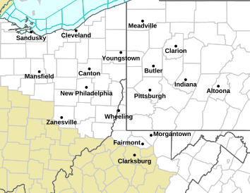
How about totals? Pittsburgh will be getting 2-4", with areas in the pink seeing 6"+! In fact, the latest NAM has up to 30" in the highest elevations of West Virginia. Temperatures will be right around freezing, or slightly above when the snow falls, so it will be a wet, sloppy snow. Areas that get 4" or more need to be prepared for power outages and widespread tree damage. Keep in mind, these trees have LEAVES on them, so just imagine piling up that much snow on them? Yep, it's going to be a mess.
HOW ABOUT INDIANA? You can breathe, now! :) No snow for us, but we will feel the storm's effects with the chilly air wrapping in on the western side of the storm. This also means very gusty winds for tomorrow and Tuesday. Even with sunshine around, highs tomorrow will be in the middle 50's, and the wind will make it feel like 40's. A little warmer on Tuesday, but still windy.
How about frost? A FREEZE WATCH has been posted for much of the state from 4am to 8am Monday morning. Temperatures will be near freezing, so COVER those plants! I almost lost my hydrangea shrub during the last freeze, so don't take a chance.
The next chance of rain arrives Wednesday into Thursday, with slightly milder air.
Behind that system? More chilly air. By next weekend, a front could stall out across the state, which already has me worried about a heavy rain threat, along with a HUGE temperature gradient. I have seen these type of set-ups bring 80's to Kentucky, and 50's in Indiana. Check out the GFS temps for next weekend:

No comments:
Post a Comment