Friday, September 30, 2011

Coldest Air of the Season - A Warm-Up Coming Soon!

Good morning! TGIF!! We are starting off our day with gloomy skies, and some sprinkles! Temperatures are in the lower 50s.

Highs today will only hit the upper 50s for many, with some spotty showers. The best chance of showers will be across the northern parts of Indiana, where there will be lake-effect showers. Oh yeah.. There's going to be a brisk wind blowing as well, adding insult to injury! Brrrrrr!!

Sunny skies return Saturday, but the chill remains! Winds will still be breezy, and highs will only hit the upper 50s!

FROST THREAT- Saturday night! Lows will dip in the middle 30s with clear skies! Be sure to cover up your plants!                                                                                                                                                                         

Sunday is going to be a nice, fall day! Lots of sunshine, with highs in the middle 60s. Winds will really die down as well.

Looking at next week, BEAUTIFUL! Yep, that pretty much sums it up! A huge ridge will build in, making for some great fall weather! Perfect weather for camping, or enjoying some of the fall colors starting to show up! Highs will range from the 70s Monday & Tuesday, then 80s Wednesday-Friday!

I will try to update again sometime today, so be sure to check back! Have a great Friday!


Thursday, September 29, 2011

Big Temperature Swings On the Way!

Good morning! It is a nice start to the day out there! Temperatures are chilly, in the upper 40s-low 50s.

Sunny skies will be the rule the first half of today, then clouds increasing by late afternoon. Winds will really begin to crank this afternoon! We will have to watch for a line of showers/storms moving through this evening, as a couple storms could reach severe limits. It will be warmer today, in the middle 70s.

A very sharp cold front is going to swing through the Ohio Valley late tonight. Winds will be howling after midnight, as we could see gusts over 30 mph!

A cloudy, cold, windy day expected for Friday! Winds will be downright gusty, making it feel colder than what the thermometer says! A few sprinkles will be possible tomorrow afternoon. Highs will be in the upper 50s!

Some sunshine should return Saturday, as the chill remains. Highs will only top out in the upper 50s!! Frost threat is HIGH on Saturday night! With clear skies & calm winds, frost will become patchy to widespread! Lows will dip in the upper 30s in the city, but low-middle 30s away from Indy. Green thumbs beware!!! Sunday should turn out pretty nice! Lots of sunshine expected, with highs in the middle 60s. The cold air for this weekend is impressive! Check out the departure from normal for this weekend:


Also, check out how far south this cold air is going! Even Florida is going to feel temperatures well below normal this weekend!

For next week, SUNNY, WARM, BEAUTIFUL DAYS EACH DAY NEXT WEEK!!! That ridge that has been in the northwest U.S. for the past month will finally build east, across the central & eastern half of the U.S.! Temperatures will warm well in the 70s, with lower 80s by the second half of next week! It looks this warm pattern may stick around for a while, too! Check out the 8-14 day outlook: (Oct. 6-12)
8 to 14 Day Outlook - Temperature Probability
It doesn't get much better than that! My only fear is that the colder air building in western Canada during this time may eventually find its way to spread into the area towards the third week of October.

Have a great Thursday, and check back for more updates here at Nate's Weather Blog!

Wednesday, September 28, 2011

Funnel Clouds Being spotted in Northern Indiana!

Good afternoon! Thanks for checking up on the blog! Another cloudy day out there, what's new? Most of the showers are being confined in northern Indiana, and - funnel clouds? Yep! We are seeing "cold air funnels" developing in just typical rain showers across northern Indiana this afternoon. NWS in northern Indiana is asking you to report to law enforcement and take shelter if you see a funnel cloud this afternoon!

An EF-0 tornado was confirmed yesterday on the east side of Nappanee, IN! Check out the rotation detected on doppler radar-12:56 pm....


For more info & some damage pictures, you can click on the link below:
http://www.crh.noaa.gov/news/display_cmsstory.php?wfo=iwx&storyid=73402&source=0

Check out this awesome view of the low-pressure on the satellite map:


Now looking ahead- Good news: Expect clouds to FINALLY clear out late tonight, setting the stage for a nice Thursday, for the most part! Highs tomorrow will the warmest in quite some time- middle 70s! Bad news: Clouds will move back in tomorrow afternoon, along with some scattered showers. A few showers possible through Thursday night.

Sharply colder for Friday and beyond! In fact, the coldest of the season. A shortwave will move through the northeastern half of Indiana Friday, so expect more clouds and showers north and east of the city Friday. Sunshine farther south and west. Highs on Friday only in the upper 50s-low 60s. For the weekend, LOTS of sunshine expected, but chilly! Saturday will only hit the upper 50s, and Sunday morning, FROST! No joke! Lows should dip in the middle upper 30s Saturday night with clear & calm conditions. Middle 60s by Sunday, but another frost threat Sunday night. Beyond that warm days well in the 70s, and comfortable, crisp nights can be expected for much of next week. We could touch 80 again by next Thursday and Friday! (:

Thanks for checking the blog, have a great evening!

Tuesday, September 27, 2011

Pattern Looking Like Fall!

Good morning! Thanks for checking the blog! Turned out to be a decent Monday, didn't it? The bad news is that the low continues to stay put in the area, meaning more rain!

Today will be a cloudy, chilly day, with occasional showers/sprinkles. No all day rains expected. More of the same can be said for Wednesday!

We should see a mix of sun/clouds return Thursday, as highs return to the middle 70s. After that, things really begin to change!

A MAJOR shot of chilly air, (the coldest of the season) is going to invade the eastern half of the U.S. from Friday right through the weekend. This type of cold air can feature a couple days with highs in the upper 50s, especially Friday & Saturday, and lows that could dip near freezing in outline areas! A widespread frost would be possible for a few mornings in a row if everything plays out! Wow, Check out these chilly numbers the GFS is showing for Friday-Sunday:


It is sure to be a cold start to October! The good news is, that we will see just gorgeous sunny skies all weekend long, making for a great weekend outdoors! Our pattern will take a flip-flop (if you will) next week, as a ridge moves in. Next week looks nothing short of FANTASTIC around here, with highs climbing back in the 70s, along with some great sunshine!

Before I go, here is what you can use to track today's showers:


Have a great Tuesday, and check back for more updates! God Bless!

Monday, September 26, 2011

A Nice Afternoon - More Rain On The Way!

Good afternoon! Hope your Monday is going great! It sure is nice to see the sunshine today! Enjoy- it's only temporary!

The upper-level low continues to sit & spin across the Ohio Valley, we a re just caught in the lucky dry slot at this time. Rain is actually not too far away, moving through Illinois. This rain should move back in late this evening, probably not until midnight in central Indiana.

Scattered showers will continue tomorrow & Wednesday, especially from I-70 north. It won't rain all day, but temperatures will stay cool, mainly middle 60s.

Temperatures will spike in the middle 70s Thursday, with some sunshine.

The weather for next weekend looks nothing short of spectacular! Despite cold mornings & potential frost, lots of sunshine expected all weekend, with highs in the upper 50s-low 60s Saturday, and mid-upper 60s Sunday. Lows will dip in the 30s!! Here is a look at the cool blast on the GFS:
GFS TMPF forecast valid 06 UTC Sat 01 Oct 2011

Thanks for checking the blog, have a great evening!!

A Nicer Day Ahead!

Good morning! First off, that was some impressive rainfall last night! Many areas picked up 1-3" of rain, with 4"+ in some locations! This is the most rainfall the area has seen since back in June! We needed that, but the grounds are very saturated now, so we need a break! Check out these rainfall totals from the past 5 days:


Many areas have seen 2-6" over the past 5 days! Wow!

A "dry slot" is moving into the area, which means we should see some sunshine today! Don't know about you, but I'm ready to see the sun again! Wouldn't rule out a sprinkle or shower this evening, but most areas will stay dry. High will hit the upper 60s.

Rain will swing back in overnight, rotating around the upper-level low. Showers will continue off and on for Tuesday. More of the same for Wednesday. I also expect things to be quite breezy the next few days. Highs will mainly be in the middle 60s.

Temperatures will spike by Thursday, in the midde 70s, along with partly sunny skies. May see a spotty shower, as a sharp cold front moves in.

After that front passes, a blast of chilly air is going to invade the eastern half of the U.S. This means highs in the low-mid 60s for Friday & Saturday, and yes-we may see the first frost of the season next weekend! The good news is that we should see plenty of sunshine with this cooler air, so it won't feel all too bad! Check out these temperature departures from normal Friday & Saturday:


That is sure going to mean a chilly start to October! The good news is that temperatures will make another rebound early next week.

Have a great Monday, & be sure to check back for more updates!

Sunday, September 25, 2011

A Rainy Afternoon!

Good afternoon! Thanks for checking up on all things weather here at my weather blog! What a nasty weekend this is turning out to be across the Hoosier state! Rain, rain, & more rain!! Temperatures are just downright chilly, in the upper 50s-low 60s.

Expect basically a steady rain all afternoon long! We have a HUGE band of moisture that continues to feed in from the south & west. Not only that, the rain gets heavier tonight! Thunderstorms with very heavy rainfall will move through tonight, dumping torrential rains for basically everybody! We will easily see a 1-3" band setting up, with localized areas seeing 4"!! Here is the latest look at the local radar:


To give you an idea of how much moisture is feeding into the Hoosier state, take a look at the regional radar:


Have a great afternoon, and check back for more updates here at Nate's Weather Blog!

Saturday, September 24, 2011

Saturday Afternoon Weather Forecast

Good afternoon! Thanks for dropping by the blog! It is pretty ugly out there across most of the Hoosier state so far! Temperatures are just plain chilly, only in the upper 50s.

As of noon, a west to east line of rain extended from Evansville to Louisville. Also, more showers near Terre Haute, Lafayette, & Crawfordsville. This pesky rain will continue to move north & east as the day wears on, with more firing up. Here is what you need to track the rain:


Also, watch out for thuderstorms beginning to develop from Terre Haute to Crawfordsville! Also, some breaks are developing in the clouds out towards Illinois. If this clearing moves in, we could see thunderstorm activity increase with the instability. Here is the latest satellite view:
East Central US Visible Satellite

You can see that big hole in the clouds across the southern half of Illinois. This may give the southern half of Indiana some sun for a while this afternoon, but it will cause storms to start firing up.

It won't be a Saturday afternoon washout anywhere in the state, but you will have to dodge rain and thunder from time to time. Rains will be steadier tomorrow.

Have a great afternoon, check back for more weather info! :)

Friday, September 23, 2011

Weekend Forecast

Good morning! Welcome to the first day of autumn! It is feeling like autumn out there this morning! Be sure to grab the jacket this morning as you head out!

Rains across eastern Indiana will continue to move out. Skies may actually become partly sunny for a while this afternoon. Highs will be in the upper 60s. Here is what you need to track the rains exit...

If you are heading out to any of the football games this evening, the weather should be pretty nice! Expect temperatures in the middle 60s.

The weekend will feature some rain around here, but certainly no washouts! Saturday will be the drier of the two days, as steadier rains are likely on Sunday. Here is your weekend forecast......

 Weekend Outlook:

 Saturday                          Sunday:
                   
More clouds than              Rain Likely. A
sun. Isolated-sct.              wet day! 1/2"+
afternoon showers.           of rain possible.
63-70.                              64-68.

If you have things you need to get done oudoors, I would do it Saturday!

The pesky, stubborn upper low will still impact our weather through Tuesday of next week. Rainfall potential over the next five days will range between 1-2" for most.

Have a great Friday, and check back for more updates here at Nate's Weather Blog!

Thursday, September 22, 2011

A Great Day Ahead - Changes On the Way!

Good morning! It is a pleasant morning across the Hoosier state, with partly cloudy skies, and pleasant temperatures in the lower 50s.

It is going to be a great day out there today! Expect partly sunny skies, and highs in the lower 70s in Indy, middle 70s south, upper 60s in northern Indiana. You can track todays temps here....
Indiana Temperature Map

Changes will begin tonight. Rain showers will move in, many across southern & eastern Indiana. This may reach Indy as well.

The weather tomorow through the weekend looks rather cool and damp. There will still be plenty of dry weather, though. Here is a preview of the weekend......

Weekend Outlook:

  Saturday:                            Sunday:
                          
       62-70                                63-70
Mostly cloudy.                   Partly-mostly cloudy.
Scattered showers,            Isolated-scattered pm
especially after noon.         showers. Dry hours
Not a washout!                 expected.

This similar pattern will stick around through early next week. After the middle of next week, a big-time warm-up looks to be underway. We look to end September, or start the month of October, with highs possibly back in the 80s!

Have a great Thursday, & check back for more updates here at Nate's Weather Blog.
                                         

Wednesday, September 21, 2011

Another Cut-Off Low In the Forecast!

Good morning! Is it just me, or is September just flying by? To me, it's hard to believe we are just a few weeks away from the peak fall colors! Speaking of fall, a fall pattern is going to take hold on our pattern through next week.

Today will be a warm day across the area, as highs near 80. A couple showers through early afternoon, otherwise partly sunny & nice!

The closed upper-low will begin to move our way tomorrow. We should start Thursday with sunny skies, but things will start to change by the afternoon. The low from the north will move south, increasing our clouds tomorrow afternoon. Highs tomorrow should be near 70.

The cloudy, drizzly, chilly wording will best describe Friday-Monday! It is not going to be the best weather weekends out there, but no washouts expected. Temps will remain generally in the 59-66 degree range. This similar pattern will stay true for Monday as well.

After the low moves out:
By the middle of next week, it looks like warm, sunny days could be in our future. In fact, much of October looks to be warmer than average, and drier than normal again. This type of pattern may get the tropics going somewhere in early October. Looking farther down the road, our weather pattern may flip flop to a very cold pattern sometime after Halloween. Despite the warmer October expected, the type of pattern I see for November may give us an increased threat of an early season snowfall. Okay.. don't let me get way to ahead of myself!!

Have a great Wednesday, & check back for more updates here at Nate's Weather Blog.

Tuesday, September 20, 2011

A Nice Day Expected - Changes on the Way!

Good morning! What a relief yesterday was! A widespread 1-2" of rain fell yesterday, really putting a dent in the ongoing drought! Spencer & Carmel both reported over 3" of rain yesterday! Here is a map of rainfall totals:


The fog and clouds should burn off, giving way to partly sunny skies this afternoon. Highs will be pleasant, in the middle-upper 70s.

Wednesday looks like another mild day, in the upper 70s. A few showers are possible late. But most can expect a pretty nice day tomorrow.

Problems in the forecast come late this week. An annoying, cut-off low will cut off the main flow, and sit right on top of Indiana. This means several days of cloudy skies, very cool temps (middle 60s), and some drizzle. And of course, it will linger through the weekend. Ugh!!!!!!!!
44peskylow

The weekend won't be a washout, but rather chilly and possibly damp. Stay tuned for more updates here at Nate's Weather Blog.

Have a great Tuesday!

Monday, September 19, 2011

Rain Update - Evening Forecast

Good afternoon. I hope everyone is enjoying the rain - because we needed it!!!! Near 1.50 has fallen in the city, which is the most rainfall Indy has had since June 20th!! Rain will be gradually ending from northwest to southeast as the evening progresses. Here is your evening forecast:

  Evening Forecast
 Rain likely through 6pm, then
 gradually ending. Partial clearing
 after 10pm.
   70-64.

Here are radars to track the rain:


Rainfall totals:


Have a great evening!
                                   

Tracking Another Heavy Rain Band

RIGHT NOW: Tracking moderate/heavy rain advancing northward from southern Indiana this morning. Also, more rain up in northern Indiana.

REST OF TODAY: The rain band in southern Indiana will spread northward, meaning the entire state can expect a widespread, soaking rain today. Don't be surprised to hear some thunder as well. Up to 1" of additional rain is possible. Parts of southwest Indiana have already picked up 2" of rain so far. Here are tracking tools for you to track the rain as the day wears on:


Rainfall totals:


Have a great day!

Rainy days & Mondays!

                   
Good morning! First off, if you don't like rainy days & Monday's, this isn't going to be a good day for you, as rain is a near guarantee today!

Indianapolis International Airport has already picked up near 1" of rain this morning! We could see an additional 1/2" or more before it all comes to an end this evening.

Skies will clear overnight, and this may lead to a fog situation overnight. Lots of sunshine will be in the forecast for Tuesday, a very nice day expected, with highs in the upper 70s, near 80.

You can track today's rain on the radar widgets on the side of the blog. Have a great day, and don't let the rainy days & Monday get you down! (:

Sunday, September 18, 2011

Your Sunday Afternoon Forecast

Good afternoon! It certainly isn't the best of Sunday's out there with the rain and clouds! Temperatures are also struggling to warm up, only in the lower-middle 60s at this noon hour.

If you are heading out today, expect mostly cloudy skies, with a few scattered showers. Highs should make it in the lower-middle 70s by early evening.

Rainfall will become widespread overnight. Rainfall will also be heavy at times, with occasional thunderstorms. With the warm front moving through, it will be a warm night, with lows in the middle 60s!

Rain is likely to start out your Monday morning, and will continue through early afternoon. By time it all ends Monday evening, a half inch to an inch of rain is likely across the entire state! This is some GREAT news, considering how dry the past few months have been! Indy will see more rain tonight than they saw for the whole month of July!

Sunshine will return on Tuesday, with highs approaching 80 degrees!

Have a great afternoon, & thanks for stopping by!

Friday, September 16, 2011

A chilly day ahead. warmer for the weekend!

Good morning! We are waking up to downright CHILLY weather this morning! Temps are in the upper 40s. Some areas dipped in the upper 30s earlier this morning!

Highs today will hit the middle 60s, with an overcast day expected. A few sprinkles can't be ruled out. It's going to definately be football weather for this Friday evening!

The weekend will be noticeably warmer! Saturday should be a nice day, with a mix of sun & clouds. It is going to be a great day for any outdoor activities tomorrow. Highs will make it into the lower 70s. Clouds return for Sunday, with a shower chance by the afternoon. The best chance of rain comes Sunday night.Temperatures Sunday afternoon will be in the middle-upper 70s.

Next week looks unsettled and warmer! We will see lows near 60, & highs near 80 for the first half of next week. Storm chance Monday, Tuesday looks dry, with chances of rain with a cold front Wednesday. Some models are showing a cut-off low for the end of next week. If this does occur, this means much cooler weather will return, with shower chances late next week. This is not a guarantee at this time. This is the 6-10 day forecast of the European model:


You can see that cut-off low setting up right over the Ohio Valley. Cut-off lows are very common in the fall. The GFS paints a good half inch or so of rain next week:


I will certainly fine tune that in the coming days.

Thanks for checking the blog, have a great Friday!! (:

Thursday, September 15, 2011

A Gorgeous, Fall-Like Afternoon!

Live Camera from Lucas Oil Stadium, Indianapolis, IN 46225
Live camera outside, showing the beautiful afternoon out there! Sunshine along with a few cirrus clouds decorating the Indy skyline. Wow, this is true fall-like air! The current temperature is 63 in Indy, with a dewpoint of 33! This is some true Canadian air for sure! It is going to be a great evening if you are heading out, the weather will certainly cooperate! Temperatures will be dropping like a rock after sunset.

4pm: Sunny, breezy & cool! Middle 60s.

6pm: Sunny, cool. Low 60s.

8pm: Mostly clear, getting chilly! Middle-upper 50s.

10pm: Clear & chilly! Upper 40s.

Be sure to grab the jacket for later this evening! Some areas may see a little coating of frost to start out tomorrow morning!

Have a great evening, thanks for checking in!

A Fall Chill!

Good morning! What a chilly start this morning! The coolest morning in Indy since May 27th. We could be approaching record level cold mornings the next couple of days!

Lots of sunshine will be the rule today, making for a beautiful, fall-like day. It will feel like a late October-early November day! Highs will hit the lower-middle 60s, but a breeze will make it feel more like 50s. It's going to be a great day for some outdoor activities!

Skies stay mainly clear tonight, making for the coldest night since sometime early last April. Lows tonight will dip in the upper 30s-low 40s. Patchy frost is possible outside of Indy metro. While it won't be a killing frost by any means, if you have potted plants outside, or tomatoes, bring them inside to be safe.

Some clouds will filter in for Friday, but it will stay dry & cool! Highs tomorrow will hit the middle 60s.

Our weekend will start out cool for Saturday morning, but will really begin to warm-up Saturday afternoon! Highs will be in the lower 70s, with lots of sunshine. Our next system will begin to move in Sunday, but rain chances will still be pretty isolated, so don't cancel plans. Highs will hit the middle 70s.

Next week will be characterized by much warmer weather for the first half of next week, with an unsettled pattern as well. We will have daily storm chances Monday-Wednesday, with highs in the upper 70s-lower 80s. You can see on the map below that a warm front will lift to our north, bringing in the warm air, with a cold front sitting to our west:
Day 6 Fronts and Pressures
That cold front will swing in late Wednesday, meaning drier and cooler after Wednesday of next week.

Have a great Thursday, check back for more updates.

Wednesday, September 14, 2011

3 years ago today.............

Three years ago today, we had the remnants of hurricane Ike move into the Ohio Valley, producing damaging, catastrophic winds. This was basically referred to as the 6-hour windstorm. I will NEVER forget that scary Sunday afternoon. You could sit and just watch trees falling before your eyes. I remember taking cover in my grandma's basement because huge pieces of debris and tree limbs were flying around, making it dangerous to walk outside. Some areas of southern Indiana saw wind gusts over 75 mph, severely damaging roof shingles of many homes. Here is a list of some wind gust recorded:


Official Observations
Indianapolis Int’l Airport – 63 MPH
Indianapolis Eagle Creek Airpark – 59 MPH
Muncie – 56 MPH
Bloomington – 54 MPH
Shelbyville – 49 MPH
Terre Haute – 48 MPH
Lafayette – 43 MPH

Here is a image of the VERY rare, tight pressure gradient over the Ohio Valley. Looks like a hurricane, doesn't it?
Visible Satellite Picture - Click to Enlarge
Another bizarre thing about this was that there was NO rainfall accompanied with these winds for southern Indiana. I remember it being partial sunshine while these high winds were blowing. The rainfall was basically in central & northwest Indiana.

Remember or not.. this was one of the craziest weather days the Ohio Valley ever experienced. To get an idea of how scary it was, you can go to youtube and look up, "hurricane ike winds in southern Indiana, Sept. 14, 2008."


Blast of Fall Chill Moving In!

Good morning! Tracking some rain/isolated storms across south central Indiana this morning. Temperatures are in the low 60s south, to low 50s north, where the front has already moved through.

It is going to be MUCH cooler today! Yesterday was day 42 of 90's this summer! Highs today will be pleasant, near 70 degrees. Rain will be likely today south of I-70, with rain chances rapidly lower Indy northward. Rain could become heavy across the southern half of the state this evening and overnight. As far as totals, Indy could see a quarter inch of rain, while areas along and south of Bloomington & Columbus could see 1/2"-1" of rain!! It is going to put a dent in the drought for southern Indiana.

Tomorrow is when the CHILL gets here! Highs tomorrow will range from the upper 50s-mid 60s. Add a stiff north wind it will feel even cooler. Skies should become partly sunny. The cool temps will hang around for Friday as well. Check out these highs the GFS is showing:


Also, temps will REALLY tank Thursday night under clear skies. Lows will dip near 43 in Indy, but outline areas can expect 30s! Patchy frost is possible, but it won't be enough to damage anything. Check out these lows for Friday morning! Even northern Alabama could dip in the upper 40s!


Weekend: The weekend is looking great, as temps moderate back in the 70's! Lots of sun can be expected for Saturday, then partly sunny for Sunday, with a chance of a shower towards the evening. All in all, it will be a great weekend to get outside!

Next Week: Temperatures will begin to go slightly above normal next week! In fact, the 80s could be returning as early as Tuesday of next week. Isolated-scattered showers are possible to begin next week.

Before I go, here are radars to track the rain today:


This radar seems to be having some feedback issues, as alot of the green stuff showing up is not rain. Here is the regional radar:


Have a great Wednesday. Check back for more updates.

Tuesday, September 13, 2011

The Ups & Downs of September!

Good morning! It is a beautiful morning out there! Temperatures in the low 70s right now, & we are going to really heat up today! Enjoy it, MAJOR changes in less than 24 hours!

Highs today should top out in the upper 80s near 90. About a 10% chance of a lonely storm popping up, again most areas can expect a dry day.

Most areas should stay dry overnight, as a cold front moves in. Lows will drop in the middle 50s. That cold front is going to stall out near the Ohio River on Wednesday. It will also be MUCH cooler tomorrow, in the upper 60s. We are going to see a wave of rain move along the front tomorrow afternoon through tomorrow night. The best chance will be south of I-70. Parts of southern Indiana could pick up over a half inch by early Thursday. Here is the hpc rainfall potential:

After that, it is all about the CHILL!! Highs Thursday will struggle to hit the lower middle 60s! With skies clearing Thursday night, we may see some patchy frost Friday morning, yes I said frost! Lows will dip in the upper 30s-low 40s! Friday should rebound nicely with sunshine. Highs will hit the middle-upper 60s.

Weekend Forecast: The weekend is looking GREAT!! Lots of sunshine will be the rule Saturday, with highs in the lower 70s. On Sunday, expect middle-upper 70s with more sunshine. Lows will be in the middle-upper 40s. The next system may "try" to sneak in Sunday evening, but really both days look great!

We are going to go from 90 today, to the cold upper 30s Friday morning! Gotta love the fight between summer & fall this time of year!

Thanks for checking the blog, have a great day!

Monday, September 12, 2011

Thoughts On Upcoming Winter

La Nina conditions have returned, meaning a similar winter to last years. Here is the usual set-up of a La Nina winter:
La Nina is Back
This means VERY wet weather across the Ohio Valley for the upcoming winter, but temps will be determined  with the position of the jet stream. In general, if the storm track shifts slightly farther north than last year, a warmer winter would be possible, with more rain than snow. If the storm track is like last years, or even farther south, a snowy and frigid winter would be in store. Only time will tell at this point. This will all be fine-tuned as we get closer to winter, but I think overall we can expect a winter much like last years.

Update on drought in parts of Indiana

After the very hot & dry July we had, drought conditions developed in Indiana. While we have had some rain in August, the drought still continued to get worse. The rainfall throughout the last week has really helped out! The grass in southern Indiana has greened back up, thanks to an inch of rain over the past week. More rain fell across parts of the state yesterday as well. We FINALLY got a good soaking rain at our house north of Martinsville yesterday, along with some storms yesterday evening across southern Indiana.

Here is a table of rainfall at different reporting sites across Indiana, and the departure from normal (from the NWS). Notice how Lafayette was the lucky spot, actually over 2" above normal:


Location
Rainfall June 1 - September 7
Departure from Normal
Same Period for  2010
Indianapolis
7.36"
-5.15"
13.14"
Lafayette
14.99" 
+2.69"
16.86"
Muncie
10.04" 
-2.64"
15.35"
Terre Haute
8.02"
-5.37"
17.52"
Bloomington
10.58" 
-2.63"
12.06"


Here is the drought status as of now:
Drought Monitor

Here is the current soil moisture (4inch depth) across the midwest:
Soil Moisture (4")

The 8-14 day outlook is showing normal to somewhat below normal rainfall:
8-14 day precipitation outlook

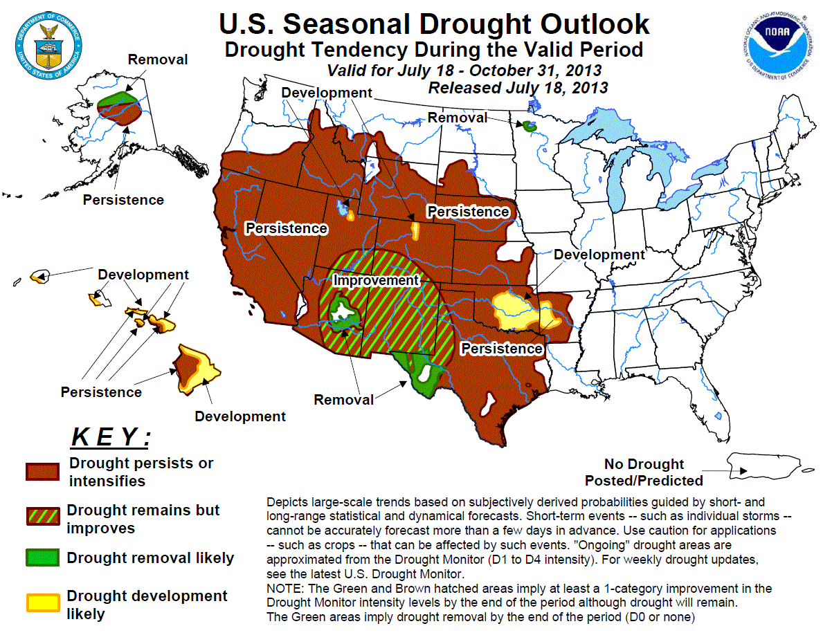
Here is the drought outlook over the next three months:
Drought Outlook

Just like last year, drought conditions will improve as we get farther into the fall. The poor drought-striken areas of Oklahoma & Texas will see little to no improvement!

I know this has been one boring post, & I apologize! :) Thanks for reading!

A great start to the week!

Good morning! I hope everyone had a great weekend, & took some time to remember the terrible tragedy on this country 10 years ago. I was so happy to hear Obama reading a scripture from Psalms at yesterday's memorial, showing we are a nation of God!

Now on to the weather...A gorgeous Monday, as summer tries to move back in for a day or so. Highs today will warm into the middle 80s. Here is today's breakdown.....

9am: 63.

11am: 74.

1pm: 79.

3pm: 82

5pm: 84

Highs: 81-87.

A clear night tonight, lows will drop near 60. We will see a mix of sun/clouds for Tuesday, with a 10% chance of seeing a shower late in the day. 90% of us can expect a dry day, with highs in the upper 80s. A few spots could touch 90 for one last time.

Behind that first front Tuesday night, it will be much cooler Wednesday, in the middle 70s. Another cold front will move in early Thursday, with a shower threat early Thursday, followed by the coolest air of the season! Highs will only hit the low-middl 60s Thursday, with lows by Friday morning near 40, with some upper 30s & patchy frost in a few outline areas! It's going to be COLD! We will warm up in the upper 60s Friday afternoon. Notice how the cool area peaks Thursday-Friday, then begins to get warmer by Saturday:


Right now, next weekend looks nothing short of gorgeous! We will see temps going back well in the 70s, with plenty of sunshine.

Have a great Monday!

Saturday, September 10, 2011

Your Sunday Forecast

Good Saturday evening! Today was by far the best weather day we have had in a while! We finally got to see some breaks of sunshine, and that's why we got so much warmer today!

Some areas saw some quick downpours this evening. Those are fading fast, and I expect skies to be partly cloudy overnight. Because we will see more clearing, light winds, and moist ground (in some spots), we will see fog develop overnight. It could be a tough drive to church in the morning, especially if you saw rain at your house today. Lows will drop in the upper 50s.
Your Sunday Forecast............

Partly Sunny, isolated-scattered pm shower. Pleasant temps! 74-80.


Friday, September 9, 2011

More of the same - warmer air for the weekend!

Good morning! It is another gloomy looking morning in the hoosier state, with some scattered sprinkles at this time, and temperatures in the lower 60s. It feels much warmer this morning without the wind blowing! Here is your Friday timeline....
Your Friday Forecast......
69°

9am: Clouds, spotty shower. 62

11am: Gloomy, sprinkles. 64

1pm: Mostly cloudy, scattered showers. 66.

3pm: Mostly cloudy, scattered showers. 68.

5pm: Peek of sun? Spotty-scattered showers. 69.

Weekend: We may have to dodge some rain for the weekend, especially tomorrow. We should break up the clouds a bit with some peeks of sunshine, which will add instability for fueling showers and even some t'storms. Some areas could see some decent rainfall. Sunday will still have a chance of seeing a few showers through the day, but drier than Saturday. Skies on Sunday should become partly sunny. Highs will be in the middle-upper 70s throughout the weekend. Some areas may see between .25-.75 of rain this weekend. Here is the GFS rainfall forecast for the weekend:


Next Week: A big warm-up will be underway to start next week. The sunshine will come back, with highs in the low 80s for Monday. Middle-upper 80s by next Tuesday, with a chance of late day storms as a front moves through. After Tuesday, gorgeous temps in the 70s will be in store for Wednesday-Friday of next week with sunshine. We could see our lows late next week really dip with the clear skies around!

Oh yeah.. before I go, here is what you need to track the showers today.....


Have a great Friday!!!!

Thursday, September 8, 2011

Evening Forecast

Good afternoon! Another day that is feeling more like late October! Temperatures are in the lower-middle 60s. Here is your evening forecast:

Thursday Evening Forecast..

Scattered showers. 60-67.

Here is the latest radar before you head out:


Have a great evening!

Another Damp & Cool Day - Improvements for the Weekend

As I type this post this morning, there are areas of light drizzle/showers out there again this morning. It is going to be another chilly day for September. Here is your timeline for today:
Your day ahead...
67°

9am: 59

11am: 62

1pm: 64

3pm: 66

5pm: 67

Friday should be slightly warmer, with more scattered showers possible. There will be some dry hours as well. The winds willl be much more lighter, so it will feel wamer out there!

Weekend: The weekend will get much warmer, and less rainy! For Saturday, expect a few peeks of sun, with some isolated-scattered showers or t'storms. Highs will hit the middle-upper 70s. Don't cancel your plans! Sunday now looks to be dry with some sunshine! Highs will near 80° !

Next Week: We will return to summer, again! Highs Monday & Tuesday could push well in the 80s! A few storms are possible late Tuesday along a front. After that, it will cool back in the 70s, but with some nice sunshine!

Tropics: We have three named storms in the tropics! We have hurricane Katia, which will not hit the U.S. There is TS Maria way behind Katia in the Atlantic. In the gulf, we have TS Nate, which will becomne a hurricane. This looks to move southwest into Mexico. I wish we could somehow steer it north into Texas, where rain is so desperately needed! It doesn't look like it will as of now.
TC Activity

Thanks for checking the blog, have a great Thursday!