Tuesday, December 31, 2019

12-31 Update: Sun Returns Wednesday - Soggy Late Week.

Good afternoon!  After our incredibly warm Christmas weather, we are feeling a reality check out there as we prepare for the New Year's!  We have plenty to track...here are some quick headlines.   


Clouds will linger through mid-morning Wednesday, then depart for a sunny & bright afternoon!  

Showers look to return Thursday afternoon across the southern half of the state, then widespread showers lift north & overspread the area Thursday night through Friday night with unseasonably mild temps.


Temperatures would drop throughout the day Saturday, as precipitation transitions to snow showers.  There remain big differences in the data, though.  The GFS is progressive and doesn't put down much accumulation.  The European REALLY wants to deepen & slow down this system which would provide a more dynamic system with backside deformation snowfall accumulations, even with fairly marginal surface temperatures (air aloft would be cold & support snow).  The Canadian model is more of a "middle-ground" between the two - suggesting snow showers Saturday with some light accumulation, especially central & north Indiana.  Will monitor closely.  Just know it turns chilly Saturday with snow showers in the forecast - and at least some potential to get some snow on on the ground.  Here is the Canadian snowfall forecast on Saturday (courtesy of Pivotal Weather):


Rainfall late Thursday through early Saturday looks to average 0.50 - 1.00", causing additional minor flood issues.  Highest totals southeast, where some higher totals are possible.


We then turn dry & relatively mild Sunday, with signals for another system next Tuesday-Wednesday.  The Canadian & European models continue to highlight a wintry system in this time-frame.


If you look at the snowfall forecast from the 51 different European ensemble members for Indianapolis, this shows the wide variability between the models regarding snowfall (from nothing to lots), but highlight 2 distinct chances...one Saturday & again next Tuesday-Wednesday.  


Temperatures over the next 15 days off the latest European Ensemble for Indianapolis:


More to come!  Have a Happy Near Year's!

Thursday, April 14, 2016

Perfect Spring Weather

Hi, everyone!  It has been a long time since I last updated this blog.  It is busy, busy as I am rounding out the spring semester of my junior year of college.  Where has the time gone?  After this summer, I will be done with my meteorology program and will attend a workshop in Starkville, MS in August to prepare me for my certification exam.  I am also obtaining a Geosciences degree and will not finish that up until a year from now.  It is mind blowing to me how quickly these past few years have gone.  It's very exciting and and scary at the same time to see the end of the college road in sight.

Let's talk about this amazing weather!  What a change from from last week.  April has been VERY chilly, running nearly 7° below average.  Interesting enough, March ended 7° above normal.  The rest of April looks MUCH different than the first half.  Warmer than average temperatures look to dominate our pattern over the next few weeks, and it's also a much drier pattern, at least through the medium range.  This is great news for the farmers!

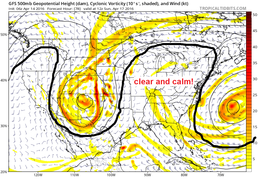
We have a blocky weather pattern in place, with the jet stream energy shunted far away from us.  An upper level low will continue to meander and weaken across the South over the next couple days.  This will try to bring a few clouds our way, mainly in southern Indiana, but we should stay dry.  As we head into the weekend, a classic Omega Block sets up.  What is that?  It is called an omega block because it looks like the greek symbol omega on a map.  Check out the map below.  It is where there is a ridge of high pressure with low pressure on both sides of the ridge.  We are going to be in the "sweet spot" with calm weather conditions - sunny and warm!  This will set us up for a perfect weekend.  


Here are the forecast specifics for the next several days....

TODAY: Sunny skies and pleasant temperatures.  Highs 65-70°.

TONIGHT: Mostly clear and not as cold.  Lows ranging from the lower to upper 40s.

FRIDAY: Mostly sunny.  Warmer.  Highs 70-73°.

FRIDAY NIGHT: Mostly clear.  Lows in the upper 40s to near 50.

SATURDAY-SUNDAY: Sunny skies.  Warm temperatures.  One of the nicest spring weekends you will ever find around here.  Highs in the low to middle 70s.  Lows in the upper 40s.

At this time, it does not appear our next chance of rain will arrive until about next Thursday.  No "major" systems are showing up anytime soon.  The long range models are showing a warmer than normal pattern for the late part of the month, and you can see this on the NOAA CPC 8-14 day outlook valid from April 21-27.  Here is the temperature forecast during that time....

Here is the precipitation outlook for the same time-frame.....


I appreciate you checking my latest blog update.  Hope you all are able to enjoy the great weather over the next several days!  

Thursday, February 11, 2016

A Frigid Weekend Coming - Snow Chances Too

Good evening, everyone.  Hope your week is going swell!  The weekend is almost here!!  It has been a very wintry week around here with bone-chilling cold and some off and on snow to deal with.  For those sick of the cold, I see a big warm-up coming late next week.  Until then, more wintry times to get through in the coming days.

I expect some light snow to impact mainly the southwest half of the state early Friday morning.  This will not amount to much at all, but some slick spots cannot be ruled out.  As we get into Friday afternoon and evening, additional snow showers are possible.  This will be another decent lake-effect snow event for far northern Indiana, a heads up if travelling that way.  Also, I would watch for a lake effect snow band to extend a pretty far distance into eastern Indiana tomorrow night.  Temperatures will drop into the single digits for Saturday morning, and expect highs to only reach the teens.  BRR!  At least we will see sunshine.

Changes start to roll in for the second half of the weekend.  We have a complicated forecast from Sunday to Monday night time-frame.  I will share my thinking based off the current data, but know that the data is still all over the place and lacking consistency from run to run.

It appears we will see a wave of light snow push in for Sunday (Valentines Day).  The trend is to speed up the arrival of the snow, now coming in around daybreak and continuing through the afternoon Sunday into the evening.  At this time I am uncertain on how much snow will fall, but at least a couple/few inches definitely appears possible.  Expect slick travel Sunday.

The trend is to develop a stronger storm to our south as we head into Monday, with the low pressure tracking through the Tennessee Valley Monday and going up the northeast Tuesday.  Will this system stay mostly to our south and not impact us?  Does it track farther north and bring decent precipitation into central and southern Indiana Monday?  The trend (if you can pick out a trend, lol) seems to be for a stronger low tracking farther north, which would bring precipitation at least into southern Indiana.  Here is the latest run of the GFS....


Graphics courtesy of WeatherBell Analytics. Taken at verbatim, there is a lot of rain with this storm to our south with a stripe of light snow on the north end across southern Indiana, and a band of heavy snow towards the Appalachians.  The models likely are likely struggling on how to handle the temperature profiles.  The EURO model brings precipitation much farther north and puts down decent snowfall across central and southern Indiana on Monday into Monday night.  I drew a map showing where the Euro puts the snow band for Monday:


Note that is only from ONE run of the model.  The next run may show no snow for us... who knows. That said, I think the latest run from the EURO makes the most sense given the pattern. Let's give the models another couple days to really show some better run to run consistency.  Again, there is still chance at this point that we see little or nothing out of this - if the "main storm" on Monday stays south.  That said, my gut tells me this will go farther north and I think central and southern sections of the state are "on the table" for some wintry precipitation out of this.  To sum it up...

Snow looking likely most of Sunday into Sunday night.  Perhaps a 1-3" event, with more north.  Amounts still questionable.  

After that wave of snow pushes out early Monday, we will have to watch to see what happens with the developing storm to our south.  The strength and track of this low is uncertain.  

I will post more updates on my Facebook page.   Have a great evening!

Monday, January 18, 2016

1/18 Monday Evening Update

Good evening, everyone.  I don't think I have to tell you its frigid outside.  BRR!  Highs struggled to reach the teens today, and tonight is yet another night with temps flirting with that 0 degree mark.

Two chances of snow this week.  One tomorrow night and Wednesday, and a stronger system to watch for Friday.  The storm for Friday will be dependent upon the eventual track of the storm and many other factors, but portions of the Ohio Valley have the potential to see a high impact winter storm during that time frame.  

First things first, let's talk about the system for tomorrow night and Wednesday:  Since yesterday, the models have trended quite a bit south with this system.  This puts the highest snow totals across western and south-central Kentucky, where several inches could fall.  Snow pushes in after midnight Tuesday night from west to east, with snow showers across central and southern portions of Indiana during the Wednesday morning commute which will make for slick travel.  Snow pushes out by late morning Wednesday.  Here is the latest snowfall map from the NAM, which is pretty close to my thinking for this event:
Map courtesy of Pivotal Weather

A model average generally has around 2" or so for Indianapolis.  Many areas across southern and southwest Indiana should see a solid 1-3". Isolated higher totals are possible across far southwest Indiana.  Heaviest in Kentucky.

Now to storm #2.  Models continue to show a storm system that would work through the Tennessee and Ohio Valley during the Thursday night through Friday night time-frame.  The northward extent of the storm is uncertain.  It would not take much of a shift in the track to put much more of Indiana in the line for impactful winter weather on Friday.  Models are indicating the potential for very heavy snow for the mid-Atlantic region extending into New England as the storm really becomes a powerhouse to our east.  Just know at this time there is potential for an impactful winter storm from parts of the Ohio Valley eastward through the mid-Atlantic and into the Northeast.  Data also suggests parts of the Ohio Valley could see some freezing rain and sleet in the mix as well.  Before I conclude this post...the evening run of the GFS just came in and is much farther north with moisture extent Friday, putting most areas along and south of I-70 in the line for accumulating snows.  Going to be fun to watch this storm over the next few days.  00z GFS posted below:

Courtesy of Tropical Tidbits


Have a great night and see you again tomorrow.  


Thursday, January 7, 2016

Watching Weekend System Rain to Snow - Interesting Pattern Setting Up for Mid-January!

Thursday, January 7....Good evening!  Rain will arrive this evening and sticks around for Friday.  The steadiest rain pushes out in the morning, however showers will hang around during the day.

All eyes on the weekend as a storm system moves through the Ohio Valley.  Rain arrives Saturday afternoon and continues through the evening.  As the low pulls north and east, colder air wraps in changing the rain over to snow showers late Saturday night with wind-driven snow showers expected across the state as you wake up Sunday morning.  Sunday will be a BRUTAL day with temps falling through the 20s with breezy conditions.  Snow showers will diminish during the afternoon.  HOW MUCH SNOW??  I still do not like to get too specific given the uncertainty in the exact track of this storm.  The models have been struggling with this storm system but seem to be getting a better handle on it.  That said, this forecast is still subject to changes.  At this time, it appears northwest Indiana could pick up at least a few inches out of this.  For the Indy metro and points south throughout southern Indiana, a general coating to 1" looks possible.  The farther north and west you go from Indy, the better the chance to receive more snow.  That is solely based off the current data.  I will be monitoring the overnight data and will post updates.  By tomorrow at this time I should have a pretty good idea how things will play out.  

COLD is the story next week.  Another arctic front will arrive on Tuesday likely bringing snow showers with it.  This will reinforce the cold air through the middle of the week.  Wednesday is looking to be the coldest day of the week.


The pattern is looking loaded with potential for fun when it comes to wintry weather around here for the middle of January.  A NICE blocking pattern showing up.  This is a pattern that can bring good winter storms in the Ohio Valley.  Will be interesting to see how things play out over the next few weeks.  


Thanks for reading!  I will have updates on my Facebook weather page and on Twitter regarding this weekend's rain to snow set-up as new model runs come in tonight.  

Saturday, November 14, 2015

Nice Sunday Before Rain Returns Next Week - Colder Changes Towards Thanksgiving?

SATURDAY NOVEMBER 14, 2015.....Hello everyone.  Here is hoping this post finds you doing well.  We started out today with the coldest readings of the season thus far.  Indianapolis dipped down to 26 this morning!  The temperature reading for Indianapolis is usually a bit warmer than surrounding areas due to the urban heat island effect - and even the "warmer" location dropped into the middle 20s last night.  Many outlying spots were in the low 20s this morning.  Very cold!!  Despite the very cold start, what a fantastic mid-November day this was.  Absolutely sunny skies, finally a day with very little wind, and temperatures that topped out in the middle to upper 50s.

Temperatures tonight will not be as cold despite clear skies.  We have a warmer air mass advecting into the area on a light south/southwest flow.  Expect lows Sunday morning to be a good 10-13 degrees warmer than what we had to deal with this morning.  Sunday looks spectacular!  Expect plenty of sunshine with highs reaching the low to mid 60s.  NOTE:  Last year during this same time we were dealing with early season snow...southern Indiana saw 3-5" of snow during the 16-17 of November 2014.

We have some mild and wet weather on the way for this upcoming week.  There will be a storm system across the Plains that will lift north and bring the potential for a good deal of rain around here.  Check out the strong southerly flow setting across our area during this time....


It appears scattered showers will begin to break out across the area on Monday, with chances increasing as we head deeper through the day.  Rain looks likely for Tuesday, with a break possible late in the day and evening hours before the rain really picks up late Tuesday night into Wednesday.    It appears that the rains will begin to pull east of here late in the day Wednesday with drying conditions Wednesday night.


How much rain could fall during this time-frame?  Anywhere from 1-3", with the higher totals the farther west you go.  Even heavier totals of 3-5" possible west and south of Indiana.

Once we get beyond this system, I do believe we will see a pattern that gradually takes on a more wintry look.  Thanksgiving week has had my attention for the past couple weeks as blocking develops over the eastern Pacific.  I think we slip into a colder than normal period that may feature our first flakes of the season at least, but can we get something more than that?  Cannot rule that out. Initially behind our system this week we will have seasonable cool air.  It appears we will have another system coming in around next weekend, and behind that is when make our way towards a potentially colder than normal period of weather.  Here is a look at the GFS ensembles 5-day average temperature anomalies from the 24 to the 29th.....


That shows much of the country dealing with colder than average temperatures for Thanksgiving week.  Now here is what the Canadian model ensembles are showing during this same time-frame...


We will see how this all plays out.  Nothing set in stone by any means, but it appears rather likely that we are going to slip into a period of colder than average temperatures during the Thanksgiving holiday time-frame.  This has been my thinking for quite some time.

Thanks for reading.  Have a fantastic rest of the weekend!

Saturday, February 14, 2015

Snow Chances On the Rise for Monday - Heavy Snow in southern Indiana??

A rare late night update tonight to make you aware that I am closely monitoring snow chances for central and especially southern Indiana late tomorrow night through the Monday evening time-frame.  Considering the noted changes in the data, I do not want anyone to feel caught off guard.  On Friday, it really looked like the bulk of any snow would stay well to the south of Indiana..with perhaps a little snow grazing southwest Indiana.  Things have certainly changed in the past 24 hours.  The model trends today and tonight are taking the snow much farther north.  To show you how much things have shifted, I put together snapshots of the last three runs of the GFS.  Shifting northward with each run....


 The model runs coming in tonight are all in very good agreement on our system for Monday bringing snowfall much farther north than earlier thought.  Since we are within about 24 hours of the event getting underway, I will go ahead and show you what some of the model data is suggesting as far as snow accumulations.  As always, I give the disclaimer that this is just forecast guidance!  

NAM model snowfall accumulations:


Graphic courtesy of Earl Barker's model page - WxCaster

This model suggests significant snow accumulations for far southern Indiana with light snow making it to about a Terre Haute to Martinsville to Franklin line.

GFS (American) model snowfall accumulations:


Graphic courtesy of Earl Barker's model page - WxCaster

GFS also suggesting significant snow amounts for far southern Indiana with light snow making it as far north as about I-70.  The entire state of Kentucky gets HAMMERED!

GEM (Canadian model) snowfall accumulations:

The Canadian model also shows heavy snow accumulations in far southern Indiana with light snow making it to the I-70 corridor.


Graphic courtesy of TropicalTidbits

ECMWF (European model) snowfall accumulations:

And the last model for the 00z data suite is in...very similar to all the other models.  Heavy snow in extreme southern Indiana.. with the potential for light snow to make it as far north as the I-70 corridor.  


Forecast uncertainties I have is how far north the snow will go....and the amount of dry air that will eat into the northern extent of the snow.  I will say this.  A lot of the models posted assume snow totals at a 10:1 snow ratio.  With very cold air in place, this will be a high snow ratio event.  With higher snow ratios you get more snow with less moisture.  Essentially "more bang for your buck."  While the cold air helps for higher snow ratios, the cold/dry air mass can also make it tough for the precipitation to overcome the dry low levels.  This will mainly be a potential issue for the northern extent of the precipitation shield.   

Bottom line: I want to be clear that I feel more and more confident that this will be a significant snowfall for portions of far southern Indiana.  The farther south you are, the more snow you will see.  ALL areas south of I-70 are now in play for the potential for some accumulating snow, with the highest confidence across far southern Indiana where this could really end up being a decent snowstorm!

Timing: It appears the snow will push into southwest Indiana at some point after midnight Sunday night, and begin to expand across southern Indiana by daybreak Monday.  The system will be at its peak throughout the day Monday with snow falling across the southern half of the state...with heavy snow possible in far southern Indiana.  There will be a sharp cut-off on the northern edge and where that sets up is to be determined.  The snow would not exit southern Indiana until at some point Monday evening into Monday night.  

Are the models done trending north?  Hmm.  Will be interesting to see if there are any additional shifts in the data tomorrow. 


Thursday, February 12, 2015

Good Thursday evening everyone! Very cold night ahead as lows drop into the singles and teens.  Friday will be slightly milder than today, with highs recovering into the upper 20s and lower 30s. Another arctic front plows through Saturday bringing snow showers and an even bigger drop in temperatures. The timing has trended slower with this front...so it appears that southern portions of Indiana may briefly rise in the low-mid 30s around midday Saturday before things crash later in the day.  It is going to be just brutal out there Saturday evening with howling winds and dangerous wind chills. Also be aware that snow showers will likely make for some slick travel during the day Saturday as well. The good news is that the snow showers should exit by the late afternoon/evening time-frame. Sunday morning will be frigid. It appears everyone will be in the single digits, with some below zero readings possible in the northern portions of the state. The wind chill [feels-like temps factoring in the wind] no doubt will be well below zero. Most of the state won't even be able to get out of the teens for highs Sunday afternoon.


As we head into next week...a southern storm system has been on the charts for a while during this time-frame.  Trends right now keep this system way south of us... with just cold/dry conditions locally next week. The system really won't get sampled until this weekend. That is when we should get some good data for this system. So bottom line....the trend is for any wintry precip to stay well south of us, but things can and will change since we are several days out.

Friday, January 30, 2015

Latest on the Weekend Winter Storm

Yesterday I said that there will likely be some shifts in the model guidance today as our weekend storm gets fully sampled.  That has indeed been the case.  The data coming in continues to trend farther north and warmer for our weekend storm.  

Precipitation will push in Saturday evening around or just after sunset.  This will likely fall as mostly snow, with some rain possibly mixed in across southern Indiana.  Here is the 12-km NAM for 10pm Saturday, showing that push of snow moving in ahead of the main system.

Nam 12-km courtesy of tropicaltidbits.com


That shield of precipitation will work northward through the night, with a lull likely across the I-70 area southward later in the night.  As we head into Sunday morning, the main system is approaching with widespread precipitation moving in.  The area of low pressure will work through southern Indiana throughout the day Sunday, bringing heavy precipitation across the state.  Likely falling as snow along/north of I-70, rain across southern Indiana.  


NAM 12-km courtesy of tropicaltidbits.com


As we head into Sunday evening, the system pushes off to our east with precipitation diminishing.  However, check out that deformation band across northern Indiana.  Northern portions of the state are in the prime spot for heavy snowfall.  It is not out of the question that locations up there could see as much as 10-12" of snow.  This is where snow will be falling for the longest duration.  


NAM 12-km courtesy of tropicaltidbits.com
  
I think this model may have the track of the low pressure just a little too far north.  However, the other models have trended closer to this more northern solution.  The BIG question is how far north will the rain/snow line get????  Some of the models now try to take it as far north as Indy on Sunday.  I want to have a good look at the 0z data that comes in tonight before making any changes to my forecast.  Just know that the TREND for this storm is farther north which brings warmer air farther north into the state.  Could it still shift a little farther south with new data tonight?  It is still possible.  Here is MY current thinking on snow totals.... 


I have a feeling there will be a sharper range in totals south of Indy than I have, but I want to see some new data tonight before making any changes.  Here are the NOAA Weather Prediction Center probability maps for at least 4" (image on the left) and the probability for at least 8" (image on the right).  


I will post updates on my Twitter and Facebook pages once some new data comes in tonight to see if there are any big changes.  

Wednesday, January 28, 2015

Watching the Weekend Closely

Good Wednesday morning.  After a cold and frosty start, today is going to be a great day with sunshine around and seasonable temperatures.  Highs will generally be in the 30s with 40s possible across southwest Indiana.  

A weak clipper will bring some light showers tonight through Thursday, mixing with snow showers tomorrow afternoon and evening.  This should not be any big deal.  At most, a very minor accumulation possible over northeast portions of the state.  Highs tomorrow will be warmer with much of central and southern Indiana reaching the 40s.

Dry and cooler weather will be the rule Friday and Saturday.  For the second half of the weekend, the main focus continues to be on a potential storm that will impact the state.  Actually, confidence is very high that there will be a storm system moving through the region on Sunday.  This has the potential to be a decent winter storm for portions of our region.  How strong will the storm become?  Where will it track?  Those are the big questions right now.  The models should gradually come into a better consensus over the next few days.  If you have plans for Sunday, you need to keep a close watch to the forecast.  

Have a great Wednesday!  

Tuesday, January 27, 2015

Warmer Mid-Week - Wintry Weather this Weekend?

Roads are slick this morning after light snow and freezing drizzle overnight.  This has caused several accidents.  Another reminder that it only takes a tiny bit to cause major problems on the roadways.  Be careful as you venture out this morning.  Conditions will improve through the day, with any lingering precipitation ending by mid-morning.  We may even see some sun later today.  

The middle of the week will feature a warming trend.  Tomorrow looks mostly sunny, with highs ranging from the upper 20s over snow-packed northeast Indiana, to around 40 in southwest Indiana.

Our next system arrives Thursday.  Precipitation may start out as some light freezing rain early Thursday mainly across the northern half of the state.  Temperatures will quickly warm into the lower 40s during the day, so any travel issues would be short-lived.   Colder air will push in on the backside of the system, meaning a transition to light snow showers Thursday evening.  

After this, all eyes will be on a potential storm system this weekend.  All three major global models now show a storm impacting the state, but solutions vary with each model.  That is to be expected when we are still five days out.  Timing of this potential system would be Saturday night through Sunday night.  

The GFS (American model) is the warmest of the models for this storm.  It tracks the low pressure up near the Ohio River.  Taken at verbatim, this would be mainly snow north of I-70, with a mainly rain event for southern Indiana.

Image courtesy of tropicaltidbits.com

The ECMWF (European model) is a colder solution.  It tracks the low from central Tennessee up through central Kentucky.  This would be a very favorable track for accumulating snow for much of Indiana. 
Image courtesy of Penn State's weather models site.

The GEM (Canadian model) is the coldest/most suppressed solution tracking the system farther south.  Taken literally, this would put the heaviest snow swath across southern Indiana and Kentucky.  

Image courtesy of tropicaltidbits.com

Remember this is just guidance.  The models will continue to waffle around over the next few days.  Right now it is feasible to say the potential is increasing for wintry weather this weekend, but many, many details to be ironed out in the days ahead.  

Have a great Tuesday!!

Monday, January 5, 2015

Winter Storm Moving In

The NOAA Storm Prediction Center has issued a mesoscale discussion highlighting all of north central Indiana for the potential of 1"+ per hour snowfall rates tonight.


Here is the look at the winter weather advisories/winter storm warnings issued from the NWS.... 


As of 8pm snow is quickly moving into central Indiana.  Snow will fall heaviest from 10pm through 3am then begin to taper off.  We certainly can't complain about the timing - considering most of the snow falls while we are asleep and by the morning commute there will only be lingering flurries or light snow at best.  That said, still plan for a very tricky morning commute.  Here is my snowfall forecast.  A good 4-6" seems like a solid call for Indianapolis northward throughout north central Indiana.  I do think there may be a localized band or two with higher totals of 6"+ within that 4-6" area...the best chance for that will be for locations northwest of Indianapolis.  Lower confidence forecast across south central Indiana will there will be a sharp cut-off on the snow totals.  Areas south of Bedford/Mitchell completely miss out on this one.  


Once this storm moves out...it is all about the extremely cold temperatures that will stick around for the rest of the week.  More on that tomorrow.  Enjoy the snow!


Sunday, January 4, 2015

Winter Storm Watch Issued For Tomorrow Night

Good Sunday evening.  I promised an evening update, and I apologize for getting it out so late.  I will make this post quick and to the point.  As I mentioned in the title, the National Weather Service has issued winter storm watches (counties in blue) for north central and northern Indiana where there is high confidence heavy snowfall tomorrow night.  The pink area you see up towards Iowa are winter storm warnings. 


I have been looking over the data and created a snowfall potential map.  Here are some quick headlines.....

-Snow pushes in from the west after 7 tomorrow evening.

-Snow will fall heavy at times with decent banding taking place tomorrow night along and especially north of I-70.  

-This will be a light, fluffy snow that can accumulate very quickly with high snow ratios and temperatures in the teens. 

-Snow quickly exits the state around 7am Tuesday. 

-The TRACK of this clipper is crucial as there is going to be a SHARP difference in totals on the southern edge of this system.
  
-The models have been shifting this system a little further south with the last few runs.  

-At this time I think north central Indiana will stand the BEST chance for up to 6" if not localized higher amounts.  I'm talking to you Lafayette and Kokomo.  


Here is my snowfall potential map. 2-4" along the I-70 corridor, 4-6" to the north, 1-2" south to Bloomington and Columbus.  Again, a slight jog southward will make a big difference in totals for south central Indiana...


I will have an update in the morning.  Take care.  

Latest on Monday night - Tuesday Snow

Good Sunday afternoon, everyone.  All eyes are on a clipper system that is set to arrive tomorrow night into Tuesday.  This system looks to put down a decent amount of snow for central and northern Indiana.

The data continues to be in pretty good agreement on the track of this system.  Here is the snowfall potential map from the GFS.  It puts down a good 4-6" snow for a good part of central and northern Indiana with a sharp cut-off across south central Indiana.  

Here is a look at the 4-km NAM.  It shows a 4"+ snow band north of I-70.  Note the very sharp cut-off on the southern edge!!


This is one of those snow events where we will be dealing with a drastic difference in snow totals from county to another.  One county can get 5" of snow and a county just south of there could have hardly anything at all.  Here is a look at my current thinking for snowfall totals.... 


Again this could EASILY shift a bit.  Overall, the latest trends have been taking this system a touch farther south, so something to watch.  I will have another update this evening.  Have a great Sunday afternoon!

Saturday, January 3, 2015

Eyeing Monday night & Tuesday Snow Potential - Dangerous Cold Coming Mid/Late Week

It has been a soggy Saturday.  Radar estimates indicate anywhere from 1" to 2.5" of rain has fallen today across south central and southern Indiana.  


Thankfully the axis of the heaviest rain is shifting east tonight.  Temperatures will begin to drop off later tonight, and we will see temperatures falling throughout the day Sunday.  Expect to start the day with a few scattered showers, transition to snow showers during the afternoon and early evening.  These could drop a quick coating especially on grassy and elevated surfaces.  Any snow accumulations will stay under 1".  

A very cold air mass settles in Sunday night and Monday.  Expect a cold day Monday with highs not getting out of the teens north of I-70, with lower 20s in southern Indiana.  


All eyes are on a clipper system expected to move in from the northwest Monday night into Tuesday.  Let's dive into some of the data.  The GFS model brings in a swath of snow across central and northern Indiana. 

Graphic courtesy of tropicaltidbits.com

Here is the snowfall accumulation off the latest GFS.  It is putting down several inches of snowfall for areas along and north of the I-70 corridor with a sharp cut-off south of Indianapolis.  

GFS snow accumulation map courtesy of Earl Barker's Model Page wxcaster.com

Here is a look at the Canadian model.  Overall very similar to the GFS except it is a bit farther south.  

Image courtesy of tropical tidbits.com

Here is the snowfall accumulation map from this model.  It paints several inches of snowfall from roughly a Bloomington to Columbus line and points north.

Image courtesy of tropical tidbits.com

I will go ahead and post the NAM model too.  Note that it keeps the snow in northern Indiana, farther north than the rest of the models.  


Here is the snow accumulation from this model.  It says nothing at all for Indy metro with accumulations staying along and north of a Lafayette and Kokomo line. 

Image courtesy of wxcaster.com
My thinking?  I will say I do not buy the NAM solution keeping the snow that far north.  I think the Canadian may be a little bit too far south on the southern extent of the snow.  Overall I think the GFS idea is a decent solution right now.  If you live anywhere north of I-70, especially in north central and northern Indiana - your chances of snow are very very good.  Notice that every model I posted have several inches of snow for you.  There is going to be a sharp cut-off on the southern extent of this system, but where will that end up??  Right now I like the I-70 corridor area as a pretty good barrier between several inches of snow and very little snow to the south....but again - small deviations in the track will make a big difference.  If you live in southern Indiana, south of Bloomington/Columbus, your chances of snow are very low for this system in my opinion other than a few flurries.  Right now, early numbers would suggest a 3-6" snowfall across north central and northern Indiana.  The track of this system is not etched in stone and will be fine-tuned over the next couple of days.  

FRIGID dangerous cold moves in for the middle of the week.  Highs on Wednesday will only reach the single digits in most spots with lows below zero across the state Thursday morning.  Areas across north central and northern Indiana could see actual air temperatures drop into double digit below zero territory with the help of a decent snow pack!!  Check out the GFS numbers for Thursday morning....


These are actual air temperatures....NOT even factoring in the wind chill!  This is now just as cold as the crazy barbaric cold we had this same time last year that we thought was so crazy!  There is no way around it....dangerously cold air coming for the mid/late week.  The good news is that there will be a decent improvement in temperatures later next weekend into the following week....so this a relatively brief but very intense shot of cold air.  Make needed preparations.  

I will try to post another blog tomorrow...if not I will have updates on my Facebook weather page.  Thanks for reading and take care.